IMAGES TAKEN NEAR TO
Stamford Park Road, ALTRINCHAM, WA15 9ER
Introduction
This page details the photographs taken nearby to Stamford Park Road, WA15 9ER by members of the Geograph project.
The Geograph project started in 2005 with the aim of publishing, organising and preserving representative images for every square kilometre of Great Britain, Ireland and the Isle of Man.

There are currently over 7.5m images from over14,400 individuals and you can help contribute to the project by visiting https://www.geograph.org.uk
Image Map
Images are licensed for reuse under creativecommons.org/licenses/by-sa/2.0
Notes
- Clicking on the map will re-center to the selected point.
- The higher the marker number, the further away the image location is from the centre of the postcode.
Image Listing (36 Images Found)
Images are licensed for reuse under creativecommons.org/licenses/by-sa/2.0
Image
Details
Distance
1
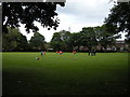
Playing Field, Stamford Park
Football practice on the playing field in Stamford Park. The houses beyond are in Queens Road.
Image: © Richard Sutcliffe
Taken: 19 Jun 2015
0.00 miles
3
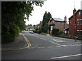
Queens Road
Queens Road from Stamford Park Road.
Image: © Richard Sutcliffe
Taken: 19 Jun 2015
0.09 miles
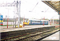
4
Altrincham.
An L.R.V.set, based in Manchester, at a Station shared with B.R. I would suspect that the L.R.V's. run on ex-B.R. right-of-way??
Image: © Ron Hann
Taken: Unknown
0.09 miles
5
Altrincham.
Another variety of B.R. self-propelled stock.
Image: © Ron Hann
Taken: Unknown
0.09 miles
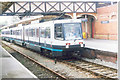
6
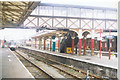
Altrincham.
A general view of the Station with the B.R. section to the right.
Image: © Ron Hann
Taken: Unknown
0.09 miles
7
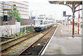
Altrincham.
A set of L.R.V.'s setting off back to Manchester. The B.R. tracks are on the right-hand side of the Platform on which I was standing.
Image: © Ron Hann
Taken: Unknown
0.09 miles
8
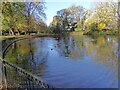
Former bathing pool
In Stamford Park
Image: © Kevin Waterhouse
Taken: 10 Nov 2023
0.13 miles
9
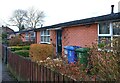
Affordable Housing
These were the first, post-war 'Prefabs' to be built in Altrincham, to relieve the acute housing shortage created by German bombing - aimed at the nearby armaments factories in Broadheath.
When first erected, in the 1940s, they consisted of naked concrete panels slotted together on site. More recently, they received brick cladding, which improved both the aesthetics and the insulation.
They were on the corner of the street leading to the then Altrincham Gas Works, and rail tracks - set into the roadway of Moss Lane - periodically carried coal wagons from Altrincham to the Works, past their front doors.
Image: © Anthony O'Neil
Taken: 25 Feb 2024
0.15 miles
10
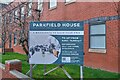
Parkfield House, Moss Lane
For many years, these were the premises of Henry Bannerman & Sons, 1805, who were one of the leading cotton spinners and textile manufacturers in the North West. Their factory here produced 'Banner' shirts and their textile warehouse was at York Street, Manchester.
Image: © Anthony O'Neil
Taken: 25 Feb 2024
0.16 miles