IMAGES TAKEN NEAR TO
Leigh Road, ALTRINCHAM, WA15 9BD
Introduction
This page details the photographs taken nearby to Leigh Road, WA15 9BD by members of the Geograph project.
The Geograph project started in 2005 with the aim of publishing, organising and preserving representative images for every square kilometre of Great Britain, Ireland and the Isle of Man.

There are currently over 7.5m images from over14,400 individuals and you can help contribute to the project by visiting https://www.geograph.org.uk
Image Map
Images are licensed for reuse under creativecommons.org/licenses/by-sa/2.0
Notes
- Clicking on the map will re-center to the selected point.
- The higher the marker number, the further away the image location is from the centre of the postcode.
Image Listing (141 Images Found)
Images are licensed for reuse under creativecommons.org/licenses/by-sa/2.0
Image
Details
Distance
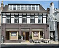
2
Westgate, Hale
Direct route from Ashley Road to Hale Road
Image: © Anthony O'Neil
Taken: 21 Feb 2023
0.13 miles
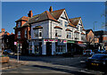
3
Quondam farmhouse
Once the property of Ollerbarrow Farm which, in former times, extended all the way to what is now Hale Road. The coming of the railway from Manchester changed everything in the late nineteenth century, and the farm eventually found itself in the heart of a thriving and expanding village. The environs of Hale remained rural well into the twentieth century, and city merchants and businessmen moved home to this salubrious suburb, building substantial villas.
For many years, Altrincham and Hale was a centre for market gardening, and at one time there were as many as twentyseven nurseries in the area.
Image: © Anthony O'Neil
Taken: 23 Feb 2023
0.14 miles
7
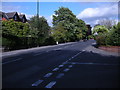
Hale Road
The junction of Hale Road (A538) and Rivington Road.
Image: © Richard Sutcliffe
Taken: 18 Jun 2015
0.15 miles
8
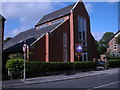
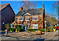
The Vine, Hale Road
Hale Methodist Church on Hale Road is now called 'The Vine'. This modern building, which also incorporates flats at the rear, replaced an earlier red-brick Methodist church on the same site.
Image: © Richard Sutcliffe
Taken: 18 Jun 2015
0.15 miles
10
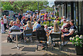
Enjoying the Sun (1)
Residents of Hale taking advantage of the first really warm, sunny day of 2024.
Image: © Anthony O'Neil
Taken: 5 May 2024
0.15 miles