IMAGES TAKEN NEAR TO
Broomfield Lane, ALTRINCHAM, WA15 9AS
Introduction
This page details the photographs taken nearby to Broomfield Lane, WA15 9AS by members of the Geograph project.
The Geograph project started in 2005 with the aim of publishing, organising and preserving representative images for every square kilometre of Great Britain, Ireland and the Isle of Man.

There are currently over 7.5m images from over14,400 individuals and you can help contribute to the project by visiting https://www.geograph.org.uk
Image Map
Images are licensed for reuse under creativecommons.org/licenses/by-sa/2.0
Notes
- Clicking on the map will re-center to the selected point.
- The higher the marker number, the further away the image location is from the centre of the postcode.
Image Listing (134 Images Found)
Images are licensed for reuse under creativecommons.org/licenses/by-sa/2.0
Image
Details
Distance
1
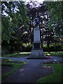
Hale War Memorial
Memorial to the men from Hale who died in both the 1914-18 and 1939-45 wars.
The memorial is situated at the junction of Hale Road and Broomfield Lane. The trees surrounding it are now quite large, and more or less hide the memorial when they are in leaf.
Image: © Richard Sutcliffe
Taken: 18 Jun 2015
0.11 miles
2
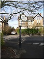
Direction Sign ? Signpost on the A538 Hale Road, Trafford
Located in Hale, on the west side of the Y junction of the A538 Hale Road and Broomfield Lane. In the former Hale parish, but now an unparished area of Trafford district. All three arms now missing and pawn finial. Manufactured by WH Smith & Co, Whitchurch, Salop.
Milestone Society National ID: CH_SJ7787
Image: © I Harwood
Taken: Unknown
0.13 miles
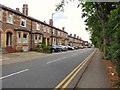
3

Detached residence
Lisson Grove, Hale
Image: © Anthony O'Neil
Taken: 21 Feb 2023
0.13 miles

6
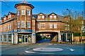
Millfield Court
Victoria Road / Lisson Grove, Hale
Image: © Anthony O'Neil
Taken: 21 Feb 2023
0.16 miles
7
Hale Road
The junction of Hale Road (A538) and Rivington Road.
Image: © Richard Sutcliffe
Taken: 18 Jun 2015
0.16 miles
8
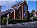
The Vine, Hale Road
Hale Methodist Church on Hale Road is now called 'The Vine'. This modern building, which also incorporates flats at the rear, replaced an earlier red-brick Methodist church on the same site.
Image: © Richard Sutcliffe
Taken: 18 Jun 2015
0.16 miles
10
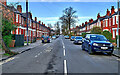
Westgate, Hale
Direct route from Ashley Road to Hale Road
Image: © Anthony O'Neil
Taken: 21 Feb 2023
0.17 miles