IMAGES TAKEN NEAR TO
Broom Road, ALTRINCHAM, WA15 9AR
Introduction
This page details the photographs taken nearby to Broom Road, WA15 9AR by members of the Geograph project.
The Geograph project started in 2005 with the aim of publishing, organising and preserving representative images for every square kilometre of Great Britain, Ireland and the Isle of Man.

There are currently over 7.5m images from over14,400 individuals and you can help contribute to the project by visiting https://www.geograph.org.uk
Image Map
Images are licensed for reuse under creativecommons.org/licenses/by-sa/2.0
Notes
- Clicking on the map will re-center to the selected point.
- The higher the marker number, the further away the image location is from the centre of the postcode.
Image Listing (129 Images Found)
Images are licensed for reuse under creativecommons.org/licenses/by-sa/2.0
Image
Details
Distance
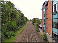
3
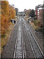
Railway line looking towards Hale Station
Looking from Hale Road bridge.
Image: © Richard Sutcliffe
Taken: 20 Nov 2016
0.12 miles
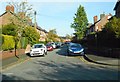
4
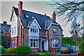
Detached residence
Lisson Grove, Hale
Image: © Anthony O'Neil
Taken: 21 Feb 2023
0.14 miles
5
Lines to Chester
The railway line to Chester from Hale Road bridge.
Image: © Gerald England
Taken: 13 Jul 2017
0.14 miles

7
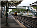
Hale Station
Chester-bound train arriving in the station.
Image: © Richard Sutcliffe
Taken: 20 Jun 2015
0.14 miles
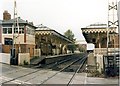
10
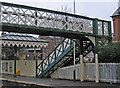
Hale - station footbridge
This footbridge, like the adjacent station buildings and canopies, is grade II listed - see http://www.heritagegateway.org.uk/Gateway/Results_Single.aspx?uid=1067918&resourceID=5 .
Image: © Dave Bevis
Taken: 16 Dec 2013
0.15 miles