IMAGES TAKEN NEAR TO
Lisson Grove, ALTRINCHAM, WA15 9AE
Introduction
This page details the photographs taken nearby to Lisson Grove, WA15 9AE by members of the Geograph project.
The Geograph project started in 2005 with the aim of publishing, organising and preserving representative images for every square kilometre of Great Britain, Ireland and the Isle of Man.

There are currently over 7.5m images from over14,400 individuals and you can help contribute to the project by visiting https://www.geograph.org.uk
Image Map
Images are licensed for reuse under creativecommons.org/licenses/by-sa/2.0
Notes
- Clicking on the map will re-center to the selected point.
- The higher the marker number, the further away the image location is from the centre of the postcode.
Image Listing (163 Images Found)
Images are licensed for reuse under creativecommons.org/licenses/by-sa/2.0
Image
Details
Distance
1
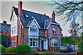
Detached residence
Lisson Grove, Hale
Image: © Anthony O'Neil
Taken: 21 Feb 2023
0.01 miles
2
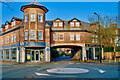
Millfield Court
Victoria Road / Lisson Grove, Hale
Image: © Anthony O'Neil
Taken: 21 Feb 2023
0.04 miles
4
Enclosed private housing
Lisson Grove, Hale
Image: © Anthony O'Neil
Taken: 26 Apr 2021
0.05 miles
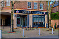
6
New Italian restaurant
Ashley Road, Hale
Image: © Anthony O'Neil
Taken: 21 Feb 2023
0.05 miles
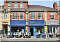
8
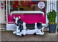
Anticipating rain?
The folk lore connecting recumbent cows with imminent rain has been discredited: this one is merely advertising fresh milk products in Hale Village.
Image: © Anthony O'Neil
Taken: 21 Feb 2023
0.06 miles
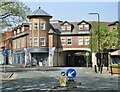
10
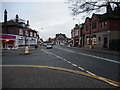
Junction of Victoria Road and Ashley Road
Looking from the level crossing at Hale Station.
Image: © Richard Sutcliffe
Taken: 18 Dec 2016
0.06 miles