IMAGES TAKEN NEAR TO
Hale Road, ALTRINCHAM, WA15 8XX
Introduction
This page details the photographs taken nearby to Hale Road, WA15 8XX by members of the Geograph project.
The Geograph project started in 2005 with the aim of publishing, organising and preserving representative images for every square kilometre of Great Britain, Ireland and the Isle of Man.

There are currently over 7.5m images from over14,400 individuals and you can help contribute to the project by visiting https://www.geograph.org.uk
Image Map
Images are licensed for reuse under creativecommons.org/licenses/by-sa/2.0
Notes
- Clicking on the map will re-center to the selected point.
- The higher the marker number, the further away the image location is from the centre of the postcode.
Image Listing (68 Images Found)
Images are licensed for reuse under creativecommons.org/licenses/by-sa/2.0
Image
Details
Distance
1
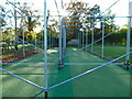
The 'nets' at Hale Barns C.C.
These tubular frames will certainly need netting attached in the Season, otherwise cricket balls will be landing in the nearby private gardens. The plastic matting is in place (presumably) all year.
Image: © Anthony O'Neil
Taken: 10 Nov 2013
0.03 miles
2
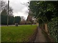
Hale Road near Hasty Lane
Looking along a pavement beside Hale Road.
Image: © DS Pugh
Taken: 21 Dec 2019
0.05 miles
3
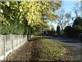
Hale Road, towards the M56 junction
All the large mansions along here - unseen to the left - are the result of the Urban District Council moving its boundaries further eastwards in 1936, allowing housing development on former Green Belt land. Hale Road itself, which was relatively rural in the 1950s, has become intensely busy due to the completion of the M56 junction (in 1972) and the continuing expansion of Manchester International Airport. There is a 1777 map of the area on which this road (towards Wilmslow) appears as "Yestow Lane". Later it became "Easter Lane" (leading to nearby Easter Farm, on the corner of Brooks' Drive). 'Yestow' is an unusual title and one wonders whether it became transformed - phonetically - into 'Easter' at some stage. 'Hale Road' is much less obscure.
Image: © Anthony O'Neil
Taken: 10 Nov 2013
0.06 miles
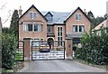
5

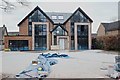
Detached house
456, Hale Road, Hale Barns: characteristic of the newer properties which have been built in the vicinity in recent years.
Image: © Anthony O'Neil
Taken: 30 Aug 2023
0.07 miles

8
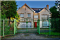
The Garden House
Hasty Lane, Hale Barns
Image: © Anthony O'Neil
Taken: 13 Feb 2023
0.09 miles
9
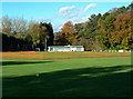
Hale Barns Cricket Ground
Clubhouse in the background
Image: © Anthony O'Neil
Taken: 10 Nov 2013
0.09 miles
10
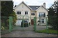
Houses of Hale Barns (16)
Hasty Lane
Image: © Anthony O'Neil
Taken: 31 Mar 2020
0.09 miles