IMAGES TAKEN NEAR TO
Shay Avenue, ALTRINCHAM, WA15 8UF
Introduction
This page details the photographs taken nearby to Shay Avenue, WA15 8UF by members of the Geograph project.
The Geograph project started in 2005 with the aim of publishing, organising and preserving representative images for every square kilometre of Great Britain, Ireland and the Isle of Man.

There are currently over 7.5m images from over14,400 individuals and you can help contribute to the project by visiting https://www.geograph.org.uk
Image Map
Images are licensed for reuse under creativecommons.org/licenses/by-sa/2.0
Notes
- Clicking on the map will re-center to the selected point.
- The higher the marker number, the further away the image location is from the centre of the postcode.
Image Listing (18 Images Found)
Images are licensed for reuse under creativecommons.org/licenses/by-sa/2.0
Image
Details
Distance
1
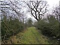
Butteryhouse Lane path
An enclosed path that appears to be an unsurfaced part of Butteryhouse Lane at Davenport Green.
Image: © Kevin Waterhouse
Taken: 5 Jan 2024
0.10 miles
2
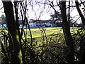
Davenport Green Hall
A view of the hall taken from the footpath on Shay Lane.
Image: © rerrits
Taken: 14 Mar 2010
0.14 miles
3
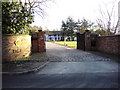
Davenport Green Hall
A view of the hall from Shay Lane.
Image: © rerrits
Taken: 14 Mar 2010
0.14 miles
4
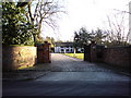
Davenport Green Hall
Looking towards the hall from Shay Lane.
Image: © rerrits
Taken: 14 Mar 2010
0.14 miles
5
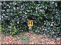
Water near here!
A marker post for a hydrant on Shay Lane near Davenport Green. SJ80348648.
Image: © Keith Williamson
Taken: 18 Oct 2005
0.15 miles
6
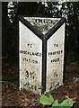
Old Milepost by Brooks Drive, Altrincham Parish
Brooks Drive bevel by the UC road, in parish of Altrincham (Trafford District), Brooks Drive; Davenport Green; 60m North of footpath to Hasty Lane opposite No. 66, on the verge.
Stolen
Milestone Society National ID: CH_BSPH03A
Image: © Mike Faherty
Taken: 25 Aug 2008
0.18 miles
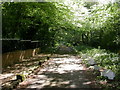
7
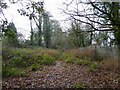
Overgrown Brooks Drive
A former tree lined carriage drive for commuters connecting Hale Barns with Brooklands railway station. This part has become overgrown since just ahead a metal security fence blocks the drive. There is also security fencing down the sides. Hopefully the blockage can be removed as Trafford Council have notices displayed about their intention to modify the definitive map to make Brooks Drive a restricted byway.
Image: © Kevin Waterhouse
Taken: 5 Jan 2024
0.19 miles

10
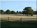
Davenport Green, Brooks Drive
Originally built by landowner Samuel Brooks in the 1860s, as a drive from Brooklands Station (built for him) South to his residence, Prospect House. Parts of the drive are now busy public road, footpath, lane or, as here, private road. Most of the houses on this section have iron railings and entryphones. Note the bank of white ramsons on the right.
Image: © Mike Faherty
Taken: 16 May 2009
0.20 miles