IMAGES TAKEN NEAR TO
Clay Lane, ALTRINCHAM, WA15 8TY
Introduction
This page details the photographs taken nearby to Clay Lane, WA15 8TY by members of the Geograph project.
The Geograph project started in 2005 with the aim of publishing, organising and preserving representative images for every square kilometre of Great Britain, Ireland and the Isle of Man.

There are currently over 7.5m images from over14,400 individuals and you can help contribute to the project by visiting https://www.geograph.org.uk
Image Map
Images are licensed for reuse under creativecommons.org/licenses/by-sa/2.0
Notes
- Clicking on the map will re-center to the selected point.
- The higher the marker number, the further away the image location is from the centre of the postcode.
Image Listing (6 Images Found)
Images are licensed for reuse under creativecommons.org/licenses/by-sa/2.0
Image
Details
Distance
1
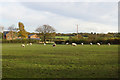
Sheep at Well Green
Surviving farmland between Hale and Wythenshawe.
Image: © Bill Boaden
Taken: 11 Nov 2017
0.07 miles
3
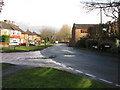
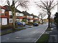
Hale - Grove Lane Meets Ash Lane
It also meets Clay Lane as Ash Lane changes its name at the junction.
Image: © Peter Whatley
Taken: 23 Jan 2009
0.11 miles
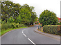
4
Road junction in Well Green
Grove Road meets Clay Lane. Well Green is a hamlet that has been absorbed into Hale suburbs.
Image: © Bill Boaden
Taken: 11 Nov 2017
0.12 miles
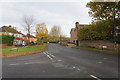
6
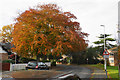
Autumnal tree in Well Green
By the side of Grove Lane.
Image: © Bill Boaden
Taken: 11 Nov 2017
0.17 miles