IMAGES TAKEN NEAR TO
Carlton Road, ALTRINCHAM, WA15 8RJ
Introduction
This page details the photographs taken nearby to Carlton Road, WA15 8RJ by members of the Geograph project.
The Geograph project started in 2005 with the aim of publishing, organising and preserving representative images for every square kilometre of Great Britain, Ireland and the Isle of Man.

There are currently over 7.5m images from over14,400 individuals and you can help contribute to the project by visiting https://www.geograph.org.uk
Image Map
Images are licensed for reuse under creativecommons.org/licenses/by-sa/2.0
Notes
- Clicking on the map will re-center to the selected point.
- The higher the marker number, the further away the image location is from the centre of the postcode.
Image Listing (24 Images Found)
Images are licensed for reuse under creativecommons.org/licenses/by-sa/2.0
Image
Details
Distance
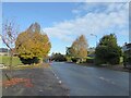
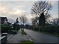
1
Briony Avenue from Woburn Drive
Looking along a street with a school on the left.
Image: © DS Pugh
Taken: 21 Dec 2019
0.16 miles
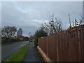
3
Briony Avenue
Looking north along Briony Avenue with Glastonbury Avenue ahead.
Image: © DS Pugh
Taken: 21 Dec 2019
0.18 miles
4
Melrose Crescent
Looking along Melrose Crescent on the northern side of Halecroft Park.
Image: © DS Pugh
Taken: 21 Dec 2019
0.18 miles
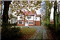
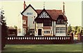
5
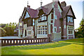
Detached Residence
Hale Road, Hale Barns
Image: © Anthony O'Neil
Taken: 7 Feb 2016
0.18 miles
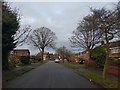
6
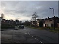
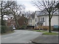
Woburn Drive
Looking along Woburn Drive near Fountain Avenue.
Image: © DS Pugh
Taken: 21 Dec 2019
0.18 miles
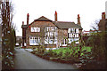
7
"Halecroft", Hale Barns
At the time of this photo, it was still a private residence but in the ensuing decades it became Council Offices and then an Architects' practice.
Image: © Anthony O'Neil
Taken: Unknown
0.19 miles
8
"Halecroft" side elevation
Hale Road, Hale Barns
Image: © Anthony O'Neil
Taken: Unknown
0.19 miles
9
Ash Lane Bus Shelter
Viewed from the end of Woburn Drive, and looking down Ash Lane in the direction of Shay Lane. The bus "shelter" offers little protection from the elements during inclement weather. The houses bordering this curving lane look out across open farmland, towards Davenport Green.
Image: © Roger May
Taken: 29 Mar 2006
0.20 miles