IMAGES TAKEN NEAR TO
Kenmore Drive, ALTRINCHAM, WA15 8QN
Introduction
This page details the photographs taken nearby to Kenmore Drive, WA15 8QN by members of the Geograph project.
The Geograph project started in 2005 with the aim of publishing, organising and preserving representative images for every square kilometre of Great Britain, Ireland and the Isle of Man.

There are currently over 7.5m images from over14,400 individuals and you can help contribute to the project by visiting https://www.geograph.org.uk
Image Map
Images are licensed for reuse under creativecommons.org/licenses/by-sa/2.0
Notes
- Clicking on the map will re-center to the selected point.
- The higher the marker number, the further away the image location is from the centre of the postcode.
Image Listing (22 Images Found)
Images are licensed for reuse under creativecommons.org/licenses/by-sa/2.0
Image
Details
Distance
1
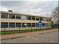
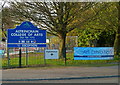
Art College
Altrincham college of Arts on Green Lane.
Image: © Roger May
Taken: 29 Mar 2006
0.02 miles
2
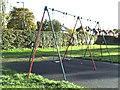
Swings in Grove Park
There has been a small recreational area hereabouts for over 50 years. Before Grove Park was created by the Council from an unredeemed portion of Hale Moss, this part was fairly rough land with a concrete slab where the previous swings were erected, oriented at 90 degrees to the present ones, and, I think, nearer to Grove Lane. (Perhaps some of the nearby houses were not yet built in the 1940s.) The old swings had solid metal rods - not chains - and unrestricted bearings, so very adventurous children could actually loop-the-loop if they had enough momentum and could hang on. I think there were accidents - which persuaded the authorities to change the design.
Image: © Anthony O'Neil
Taken: 5 Nov 2013
0.08 miles
4
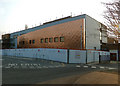
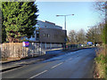
Altrincham College of Arts receives a face lift
Image: © Anthony O'Neil
Taken: 28 Mar 2011
0.09 miles
5
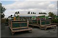
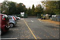
Wyevale Garden Centre
Some of the shelves are empty at this time of year in the outside sales area.
Image: © Richard Sutcliffe
Taken: 17 Oct 2015
0.10 miles
6
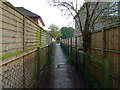
Passageway from Playing Fields to Grove Lane, Hale
Image: © Anthony O'Neil
Taken: 28 Mar 2011
0.11 miles
7
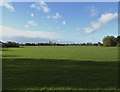
Grove Park, Altrincham
This greensward, with its public playing fields, gives no clue to its origins or earlier history. It is the remnant of what was Hale Moss: indeed, it is bordered on the south (left) partly by Moss Lane and Grove Lane. In the distance, it reaches north westwards towards Stockport Road and incorporates a golf course, cricket ground, and ornamental pool. To the far left are allotments (1914) and Altrincham Football Ground (1910). Beyond that, until dismantled, were the Gas Works (1847) and Abattoir.
In earlier centuries, it was a true moss - boggy land formed over a layer of impervious clay - with marsh, open heath, woodland and common pasture. Part of the Moss was later given to the people of Altrincham by the Earl of Stamford to form Stamford Park.
In the 19th century, near to Delahays Road (then leading to Delahays Farm), was a brick works making use of the local clay. When the works closed, it left a large clay pit which flooded to form a lake - "Gibbons' Pond". Even after the War, and into the 1950s, this was a favourite (if hazardous) play area for local children, and popular with fishermen. There was rough meadow and scrub, wild plants, and many butterflies and dragonflies. As well as footpaths criss-crossing the area, a cinder track was eventually laid from Delahays Road along the lakeside. This mini wilderness was known locally as the “Donkey Field”.
From the late 50s, it was progressively filled in with refuse by the Council, then levelled and grassed over to form Grove Park. [See also Hale Civic Society]
Image: © Anthony O'Neil
Taken: 5 Nov 2013
0.11 miles
8
Notices at the entrance to Altrincham College of Arts
Image: © Anthony O'Neil
Taken: 28 Mar 2011
0.12 miles
9
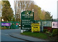
Entrance to Wyevale Garden Centre
The entrance into Altrincham Wyevale Garden Centre from Green Lane.
Image: © Richard Sutcliffe
Taken: 17 Oct 2015
0.13 miles
10
Entrance to Altrincham Garden Centre, Green Lane
Image: © Anthony O'Neil
Taken: 28 Mar 2011
0.16 miles