IMAGES TAKEN NEAR TO
Grove Lane, ALTRINCHAM, WA15 8JQ
Introduction
This page details the photographs taken nearby to Grove Lane, WA15 8JQ by members of the Geograph project.
The Geograph project started in 2005 with the aim of publishing, organising and preserving representative images for every square kilometre of Great Britain, Ireland and the Isle of Man.

There are currently over 7.5m images from over14,400 individuals and you can help contribute to the project by visiting https://www.geograph.org.uk
Image Map
Images are licensed for reuse under creativecommons.org/licenses/by-sa/2.0
Notes
- Clicking on the map will re-center to the selected point.
- The higher the marker number, the further away the image location is from the centre of the postcode.
Image Listing (30 Images Found)
Images are licensed for reuse under creativecommons.org/licenses/by-sa/2.0
Image
Details
Distance
1
Sign at Altrincham Muslim Association, Hale, Cheshire
Image: © Anthony O'Neil
Taken: 28 Mar 2011
0.06 miles
2
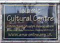
Islamic Cultural Centre, Grove Lane, Hale, Trafford
Image: © Anthony O'Neil
Taken: 28 Mar 2011
0.06 miles
3
Highfield Road towards Grove Lane, Hale
Image: © Anthony O'Neil
Taken: 28 Mar 2011
0.07 miles
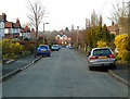
4
View down Highfield Road
Towards Grove Lane, Hale
Image: © Anthony O'Neil
Taken: 2 Feb 2013
0.10 miles
5
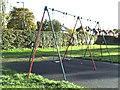
Swings in Grove Park
There has been a small recreational area hereabouts for over 50 years. Before Grove Park was created by the Council from an unredeemed portion of Hale Moss, this part was fairly rough land with a concrete slab where the previous swings were erected, oriented at 90 degrees to the present ones, and, I think, nearer to Grove Lane. (Perhaps some of the nearby houses were not yet built in the 1940s.) The old swings had solid metal rods - not chains - and unrestricted bearings, so very adventurous children could actually loop-the-loop if they had enough momentum and could hang on. I think there were accidents - which persuaded the authorities to change the design.
Image: © Anthony O'Neil
Taken: 5 Nov 2013
0.11 miles
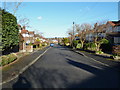
6
Highfield Road, Hale
Looking towards Grove Lane. (It is not obvious from the photo but this is quite a steep downward slope.)
Image: © Anthony O'Neil
Taken: Unknown
0.12 miles
9
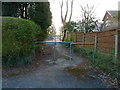
Passageway joining Grange Avenue and Highfield Road, Hale
Image: © Anthony O'Neil
Taken: 28 Mar 2011
0.15 miles
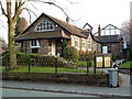
10
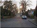
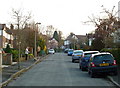
Grange Avenue, Hale, Cheshire
Typifies many of the tree lined suburban roads of Hale, with houses from the inter-war period.
Image: © Anthony O'Neil
Taken: 28 Mar 2011
0.15 miles