IMAGES TAKEN NEAR TO
Linden Avenue, ALTRINCHAM, WA15 8HA
Introduction
This page details the photographs taken nearby to Linden Avenue, WA15 8HA by members of the Geograph project.
The Geograph project started in 2005 with the aim of publishing, organising and preserving representative images for every square kilometre of Great Britain, Ireland and the Isle of Man.

There are currently over 7.5m images from over14,400 individuals and you can help contribute to the project by visiting https://www.geograph.org.uk
Image Map
Images are licensed for reuse under creativecommons.org/licenses/by-sa/2.0
Notes
- Clicking on the map will re-center to the selected point.
- The higher the marker number, the further away the image location is from the centre of the postcode.
Image Listing (29 Images Found)
Images are licensed for reuse under creativecommons.org/licenses/by-sa/2.0
Image
Details
Distance
1
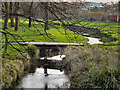
Timperley Brook
Timperley Brook passing through Altrincham Golf Course.
Image: © David Dixon
Taken: 12 Jan 2012
0.10 miles
2
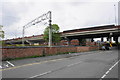
Grosvenor Road going under Woodlands Road
The flyover carries the A560, Woodlands Road, while the Metrolink line runs next to Grosvenor Road.
Image: © Bill Boaden
Taken: 2 May 2015
0.11 miles
3
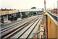
Altrincham approach
The expanded track layout at the site of Altrincham level crossing, with the enormous new footbridge which replaced that crossing for foot traffic. The residents of houses to the left objected animatedly to the new bridge on the grounds that people could hang about on the bridge and look into their houses.
Image: © Peter Whatley
Taken: 21 Jul 1991
0.14 miles
4
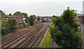
Lines out of Altrincham
The railway lines North out of Altrincham from the footbridge between Grosvenor Road and Outfield Road.
Image: © Gerald England
Taken: 27 Jun 2009
0.19 miles
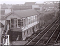
5
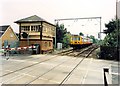
Navigation Road signalbox
Closed as part of the resignalling scheme associated with downgrading the Manchester-Altrincham route to a tram line in 1992/93.
Image: © Peter Whatley
Taken: 25 Jun 1988
0.20 miles
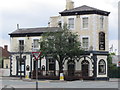
7
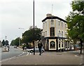
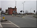
Barrington's Hotel
At the corner of Barrington Road and Grosvenor Road.
Image: © Gerald England
Taken: 27 Jun 2009
0.21 miles
8
Altrincham North signal box
Beside the level crossing north of Altrincham Station.
Image: © Richard Sutcliffe
Taken: Unknown
0.21 miles