IMAGES TAKEN NEAR TO
Osborne Road, ALTRINCHAM, WA15 8EU
Introduction
This page details the photographs taken nearby to Osborne Road, WA15 8EU by members of the Geograph project.
The Geograph project started in 2005 with the aim of publishing, organising and preserving representative images for every square kilometre of Great Britain, Ireland and the Isle of Man.

There are currently over 7.5m images from over14,400 individuals and you can help contribute to the project by visiting https://www.geograph.org.uk
Image Map
Images are licensed for reuse under creativecommons.org/licenses/by-sa/2.0
Notes
- Clicking on the map will re-center to the selected point.
- The higher the marker number, the further away the image location is from the centre of the postcode.
Image Listing (191 Images Found)
Images are licensed for reuse under creativecommons.org/licenses/by-sa/2.0
Image
Details
Distance
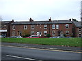
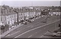
3
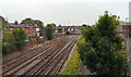
Lines out of Altrincham
The railway lines North out of Altrincham from the footbridge between Grosvenor Road and Outfield Road.
Image: © Gerald England
Taken: 27 Jun 2009
0.06 miles
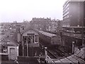
4
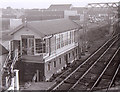
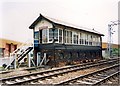
Altrincham North signal box
Beside the level crossing north of Altrincham Station.
Image: © Richard Sutcliffe
Taken: Unknown
0.06 miles
5
Oakfield Street, Altrincham
Looking towards the gasometers and telecommunications tower beside Moss Lane.
Image: © Richard Sutcliffe
Taken: Unknown
0.07 miles
6
British Rail Class 310 at Altrincham
British Rail Class 310 No. 079 passes Altrincham North signal box, heading towards Manchester.
The building to the left of the signal box was T. Cheetham & Co Fuel Distributors, one of several coal merchants which used to operate beside the station.
Image: © Richard Sutcliffe
Taken: Unknown
0.07 miles
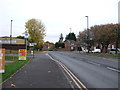
7
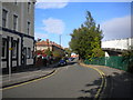
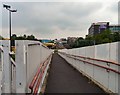
South end of Grosvenor Road, Altrincham
Just outside the town centre, with residential development on the west side and the railway line behind the foliage on the east. The white railings on the right line the ramp of a footbridge across the railway.
Image: © Richard Vince
Taken: 12 Oct 2013
0.08 miles
8
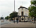
Barrington's Hotel
At the corner of Barrington Road and Grosvenor Road.
Image: © Gerald England
Taken: 27 Jun 2009
0.08 miles
9
Altrincham North signalbox
Controlled the junction and level crossing at the north end of Altrincham station. Eventually the delays to road traffic with up to 12 trains per hour became intolerable and the level crossing was replaced by the current bridge. The signalbox disappeared as part of the work to downgrade the Manchester-Altrincham route to a tram service.
Image: © Peter Whatley
Taken: 25 Jun 1988
0.08 miles
10
Towards Altrincham Station
Looking down the ramp of the footbridge from Grosvenor Road to Outfield Road, towards Altrincham Station.
Image: © Gerald England
Taken: 27 Jun 2009
0.08 miles