IMAGES TAKEN NEAR TO
Delahays Drive, ALTRINCHAM, WA15 8DP
Introduction
This page details the photographs taken nearby to Delahays Drive, WA15 8DP by members of the Geograph project.
The Geograph project started in 2005 with the aim of publishing, organising and preserving representative images for every square kilometre of Great Britain, Ireland and the Isle of Man.

There are currently over 7.5m images from over14,400 individuals and you can help contribute to the project by visiting https://www.geograph.org.uk
Image Map
Images are licensed for reuse under creativecommons.org/licenses/by-sa/2.0
Notes
- Clicking on the map will re-center to the selected point.
- The higher the marker number, the further away the image location is from the centre of the postcode.
Image Listing (28 Images Found)
Images are licensed for reuse under creativecommons.org/licenses/by-sa/2.0
Image
Details
Distance
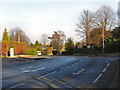
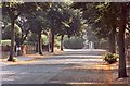
3
Hale Road (A538)
The junction of the A538, Hale Road, with the A5144, Delahays Road.
Image: © David Dixon
Taken: 16 Jan 2012
0.11 miles
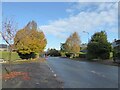
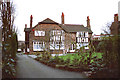
4
Around Hale Barns (18)
'Hill Top House', Hill Top
Image: © Anthony O'Neil
Taken: 25 Mar 2022
0.17 miles
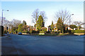
5
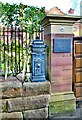
Around Hale Barns (19)
Exotic post box, Hill Top
Image: © Anthony O'Neil
Taken: 25 Mar 2022
0.17 miles
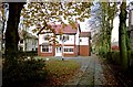
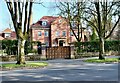
7
Detached Residence
Hale Road, Hale Barns
Image: © Anthony O'Neil
Taken: 7 Feb 2016
0.18 miles
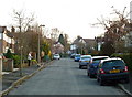
8
Grange Avenue, Hale
Looking towards Highfield Road. (A short entry joins the two.)
Image: © Anthony O'Neil
Taken: Unknown
0.19 miles
10
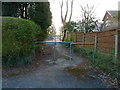
Passageway joining Grange Avenue and Highfield Road, Hale
Image: © Anthony O'Neil
Taken: 28 Mar 2011
0.20 miles