IMAGES TAKEN NEAR TO
Lilac Road, ALTRINCHAM, WA15 8BJ
Introduction
This page details the photographs taken nearby to Lilac Road, WA15 8BJ by members of the Geograph project.
The Geograph project started in 2005 with the aim of publishing, organising and preserving representative images for every square kilometre of Great Britain, Ireland and the Isle of Man.

There are currently over 7.5m images from over14,400 individuals and you can help contribute to the project by visiting https://www.geograph.org.uk
Image Map
Images are licensed for reuse under creativecommons.org/licenses/by-sa/2.0
Notes
- Clicking on the map will re-center to the selected point.
- The higher the marker number, the further away the image location is from the centre of the postcode.
Image Listing (45 Images Found)
Images are licensed for reuse under creativecommons.org/licenses/by-sa/2.0
Image
Details
Distance
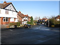
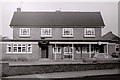
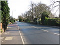
3
Moss Lane
A suburban through road between Altrincham and Hale.
Image: © Bill Boaden
Taken: 11 Nov 2017
0.11 miles
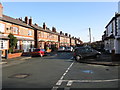
4
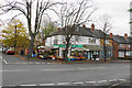
Corner shop on Moss Lane
Quite an isolated retail outlet in mostly residential suburbs.
Image: © Bill Boaden
Taken: 11 Nov 2017
0.11 miles
5

Sign at Altrincham Muslim Association, Hale, Cheshire
Image: © Anthony O'Neil
Taken: 28 Mar 2011
0.11 miles
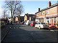
6
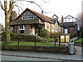
Islamic Cultural Centre, Grove Lane, Hale, Trafford
Image: © Anthony O'Neil
Taken: 28 Mar 2011
0.11 miles
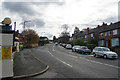
8
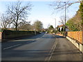
Hale Road, looking west
Taken at the junction with Egerton Road.
Image: © Peter Whatley
Taken: 20 Jan 2009
0.13 miles
9
Hale Road, looking east
Taken near the junction with Hermitage Road. Hale cemetery is on the right.
Image: © Peter Whatley
Taken: 20 Jan 2009
0.15 miles