IMAGES TAKEN NEAR TO
Cleveland Road, ALTRINCHAM, WA15 8AY
Introduction
This page details the photographs taken nearby to Cleveland Road, WA15 8AY by members of the Geograph project.
The Geograph project started in 2005 with the aim of publishing, organising and preserving representative images for every square kilometre of Great Britain, Ireland and the Isle of Man.

There are currently over 7.5m images from over14,400 individuals and you can help contribute to the project by visiting https://www.geograph.org.uk
Image Map
Images are licensed for reuse under creativecommons.org/licenses/by-sa/2.0
Notes
- Clicking on the map will re-center to the selected point.
- The higher the marker number, the further away the image location is from the centre of the postcode.
Image Listing (35 Images Found)
Images are licensed for reuse under creativecommons.org/licenses/by-sa/2.0
Image
Details
Distance
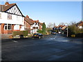
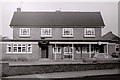
2
Corner shop on Moss Lane
Quite an isolated retail outlet in mostly residential suburbs.
Image: © Bill Boaden
Taken: 11 Nov 2017
0.05 miles
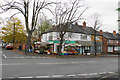
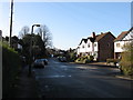
3
Moss Lane
A suburban through road between Altrincham and Hale.
Image: © Bill Boaden
Taken: 11 Nov 2017
0.06 miles
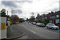
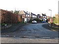
4
Moss Lane, Hale
Looking towards Altrincham Football Club's ground.
Image: © Richard Sutcliffe
Taken: Unknown
0.07 miles
8
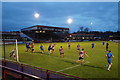
Football match at the J Davidson Stadium
A cup tie between Altrincham and Ramsbottom Utd.
Image: © Bill Boaden
Taken: 11 Nov 2017
0.12 miles
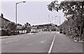
9
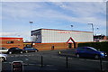
The J Davidson Stadium
The home of Altrincham AFC.
Image: © Bill Boaden
Taken: 11 Nov 2017
0.13 miles
10
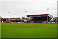
Football match at the J Davidson Stadium
A cup tie between Altrincham and Ramsbottom Utd.
Image: © Bill Boaden
Taken: 11 Nov 2017
0.14 miles