IMAGES TAKEN NEAR TO
Kelsall Drive, ALTRINCHAM, WA15 7XE
Introduction
This page details the photographs taken nearby to Kelsall Drive, WA15 7XE by members of the Geograph project.
The Geograph project started in 2005 with the aim of publishing, organising and preserving representative images for every square kilometre of Great Britain, Ireland and the Isle of Man.

There are currently over 7.5m images from over14,400 individuals and you can help contribute to the project by visiting https://www.geograph.org.uk
Image Map
Images are licensed for reuse under creativecommons.org/licenses/by-sa/2.0
Notes
- Clicking on the map will re-center to the selected point.
- The higher the marker number, the further away the image location is from the centre of the postcode.
Image Listing (25 Images Found)
Images are licensed for reuse under creativecommons.org/licenses/by-sa/2.0
Image
Details
Distance
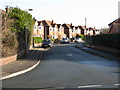
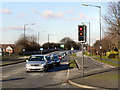
2
Bedford Drive, Timperley
Kelsall Drive enters from the right.
Image: © Peter Whatley
Taken: 20 Jan 2009
0.06 miles
3
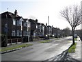
Bedford Drive, Timperley - the southern extremity
Image: © Peter Whatley
Taken: 20 Jan 2009
0.08 miles
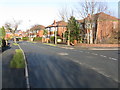
4
Flats on Aimson Road West, Timperley
Stockport Road is the through route in the foreground.
Image: © Peter Whatley
Taken: 20 Jan 2009
0.10 miles
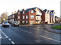
6
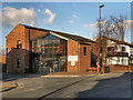
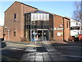
Timperley Library
The Modern library building at 405 Stockport Road, on the corner of Baker Street in Timperley.
Image: © David Dixon
Taken: 1 Feb 2012
0.13 miles
7
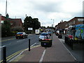
Stockport Road, Timperley, from near the Library
Image: © ray blow
Taken: 24 Jul 2007
0.13 miles
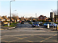
10
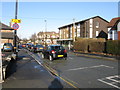
Thorley Lane, Timperley
The crossroads at the centre of "Timperley Village" is directly ahead.
Image: © Peter Whatley
Taken: 20 Jan 2009
0.14 miles