IMAGES TAKEN NEAR TO
Mossfield Road, ALTRINCHAM, WA15 7DN
Introduction
This page details the photographs taken nearby to Mossfield Road, WA15 7DN by members of the Geograph project.
The Geograph project started in 2005 with the aim of publishing, organising and preserving representative images for every square kilometre of Great Britain, Ireland and the Isle of Man.

There are currently over 7.5m images from over14,400 individuals and you can help contribute to the project by visiting https://www.geograph.org.uk
Image Map
Images are licensed for reuse under creativecommons.org/licenses/by-sa/2.0
Notes
- Clicking on the map will re-center to the selected point.
- The higher the marker number, the further away the image location is from the centre of the postcode.
Image Listing (8 Images Found)
Images are licensed for reuse under creativecommons.org/licenses/by-sa/2.0
Image
Details
Distance
3
Broomwood Post Office
The "one-stop" convenience store on Briarfield Road Image includes the local Post Office.
Image: © Gerald England
Taken: 5 Sep 2016
0.20 miles
4
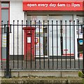
George VI postbox (WA15 31)
George VI postbox (WA15 31) outside the Broomwood Post Office Image
Image: © Gerald England
Taken: 5 Sep 2016
0.20 miles
5
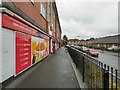
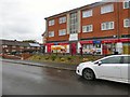
Shops on Briarfield Road
At the end of the row of shops on Briarfield Road, Broomwood Image is a convenience store under the One-Stop franchise which includes the local Post Office. Outside it is a George VI postbox (WA15 31) Image
Image: © Gerald England
Taken: 5 Sep 2016
0.22 miles
6
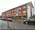
A row of shops on Briarfield Road, Broomwood
At one end is the G-Force Internet Café http://web.archive.org/web/20161015045227/http://www.gforcecafe.co.uk/ which is run by G-Force a charity set up to support young people and adults living in disadvantaged communities in South Trafford.
Next to that is the Broomwood Pharmacy http://broomwoodpharmacy.thepharmacycentre.com/ which was established in 1959 and is one of the few remaining independent community pharmacies in the area.
Next to that is a takeaway that seems to have recently changed its name from "The Unique Fish Bar" to "vivienne".
At the end is a convenience store under the One-Stop franchise which includes the local Post Office Image
Image: © Gerald England
Taken: 5 Sep 2016
0.22 miles
7
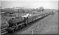
Westbound coal train at Baguley, Cheshire Lines
View eastward, towards Stockport on the important CLC line linking Liverpool via Glazebrook with Stockport and the ex-GC Manchester - Sheffield main line at Godley Junction. A coal train from Yorkshire is proceeding towards Liverpool, headed by Stanier 8F 2-8-0 No. 48501. This engine was built at Darlington in 1944 and was employed on the LNER until acquired by the LMSR in 10/46, remaining on BR(LMR) until withdrawn in 7/67.
Image: © Ben Brooksbank
Taken: 5 May 1965
0.22 miles
8
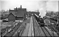
Baguley Station
View from A5103 bridge eastward towards Stockport on former Cheshire Lines main line Glazebrook - Stockport (Tiviot Dale) - Godley Junction. A heavy Peak Forest - Northwich (ICI Winnington) limestone train is passing, hauled by a Class 8F 2-8-0. The station was closed in November 1964.
Image: © Ben Brooksbank
Taken: 18 Apr 1962
0.25 miles