IMAGES TAKEN NEAR TO
Woodhouse Lane East, ALTRINCHAM, WA15 6AN
Introduction
This page details the photographs taken nearby to Woodhouse Lane East, WA15 6AN by members of the Geograph project.
The Geograph project started in 2005 with the aim of publishing, organising and preserving representative images for every square kilometre of Great Britain, Ireland and the Isle of Man.

There are currently over 7.5m images from over14,400 individuals and you can help contribute to the project by visiting https://www.geograph.org.uk
Image Map
Images are licensed for reuse under creativecommons.org/licenses/by-sa/2.0
Notes
- Clicking on the map will re-center to the selected point.
- The higher the marker number, the further away the image location is from the centre of the postcode.
Image Listing (9 Images Found)
Images are licensed for reuse under creativecommons.org/licenses/by-sa/2.0
Image
Details
Distance
1
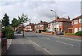
Riddings Road, Timperley
Semi-detached houses on a bend in the northwest corner of the square.
Image: © Derek Harper
Taken: 18 Aug 2010
0.22 miles
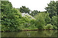
2
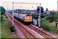
Suburban Sale
Railway, canal and inter-war housing between Sale and Timperley.
Image: © Peter Whatley
Taken: Unknown
0.22 miles
3
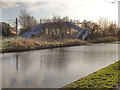
Footbridge over the Metrolink
A footbridge crossing the Metrolink tramway, alongside the Bridgewater Canal, between Brooklands and Timperley.
Image: © David Dixon
Taken: 12 Jan 2012
0.23 miles
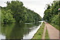
5
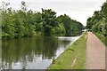
Bridgewater Canal
Walkers on the Bridgewater Way, the towpath of the Bridgewater Canal between Timperley and Brooklands.
Image: © David Dixon
Taken: 12 Jan 2012
0.24 miles
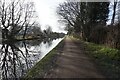
6
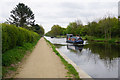
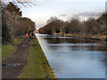
Narrowboat on the Bridgewater Canal
This is a very long straight section of the canal.
Image: © Bill Boaden
Taken: 2 May 2015
0.24 miles