IMAGES TAKEN NEAR TO
Warburton Drive, ALTRINCHAM, WA15 0SL
Introduction
This page details the photographs taken nearby to Warburton Drive, WA15 0SL by members of the Geograph project.
The Geograph project started in 2005 with the aim of publishing, organising and preserving representative images for every square kilometre of Great Britain, Ireland and the Isle of Man.

There are currently over 7.5m images from over14,400 individuals and you can help contribute to the project by visiting https://www.geograph.org.uk
Image Map
Images are licensed for reuse under creativecommons.org/licenses/by-sa/2.0
Notes
- Clicking on the map will re-center to the selected point.
- The higher the marker number, the further away the image location is from the centre of the postcode.
Image Listing (7 Images Found)
Images are licensed for reuse under creativecommons.org/licenses/by-sa/2.0
Image
Details
Distance
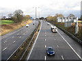
2
Queue!
Warburton Green: Manchester-bound traffic on the M56 approaches the turn-off for Hale Barns and Wilmslow.
Image: © Anthony O'Neil
Taken: 18 Aug 2022
0.16 miles

4
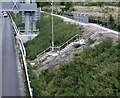
Staircase to danger?
During the course of M56 motorway development, the public footpath adjacent to Halebank Farm has been concreted and these steps are being added ... although why anyone would want, or need, to walk over the carriageway is something of a mystery, especially as there is a road bridge within fifty yards.
Image: © Anthony O'Neil
Taken: 18 Aug 2022
0.19 miles
5
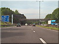
M56, Warburton Green
The bridge connects Chapel Lane at Warburton Green with Sunbank Lane at Halebank.
Image: © David Dixon
Taken: 4 Sep 2010
0.19 miles
6
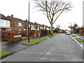
The Name Changes
Ridge Road becomes Gorse Bank Road at a seemingly arbitrary point along this suburban road.
Image: © Peter Whatley
Taken: 23 Jan 2009
0.21 miles
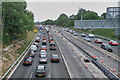
7

On the central reservation
Looking westbound: the culmination of several years development of the M56 between Hale Barns and Ashley.
Image: © Anthony O'Neil
Taken: 18 Aug 2022
0.21 miles