IMAGES TAKEN NEAR TO
Burnside, ALTRINCHAM, WA15 0SG
Introduction
This page details the photographs taken nearby to Burnside, WA15 0SG by members of the Geograph project.
The Geograph project started in 2005 with the aim of publishing, organising and preserving representative images for every square kilometre of Great Britain, Ireland and the Isle of Man.

There are currently over 7.5m images from over14,400 individuals and you can help contribute to the project by visiting https://www.geograph.org.uk
Image Map
Images are licensed for reuse under creativecommons.org/licenses/by-sa/2.0
Notes
- Clicking on the map will re-center to the selected point.
- The higher the marker number, the further away the image location is from the centre of the postcode.
Image Listing (44 Images Found)
Images are licensed for reuse under creativecommons.org/licenses/by-sa/2.0
Image
Details
Distance
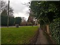
1
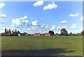
On the fringes of Hale Barns
View of distant Pennine hills still possible from the 'green belt' despite building development in many parts.
Image: © Anthony O'Neil
Taken: 1 Jun 1971
0.09 miles
5
Hale Road near Hasty Lane
Looking along a pavement beside Hale Road.
Image: © DS Pugh
Taken: 21 Dec 2019
0.12 miles
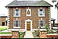
7

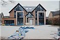
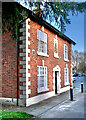
Detached house
456, Hale Road, Hale Barns: characteristic of the newer properties which have been built in the vicinity in recent years.
Image: © Anthony O'Neil
Taken: 30 Aug 2023
0.12 miles
8
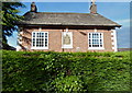
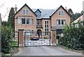
Listed but disappearing
The former Buck Hall Farmhouse is now almost entirely obscured by hedging. (See other photos, in this square, from an earlier era, when the period facade was fully visible.)
Image: © Anthony O'Neil
Taken: 22 May 2016
0.13 miles
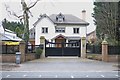
10
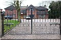
Florentine restaurant, Hale Barns
The 'San Carlo' occupies the historic 'Buck Hall' - the former farm on which the adjacent Marriott Hotel was built. For details of the original building see: Image
Image: © Anthony O'Neil
Taken: 13 Feb 2023
0.13 miles