IMAGES TAKEN NEAR TO
Mill Lane, ALTRINCHAM, WA15 0RE
Introduction
This page details the photographs taken nearby to Mill Lane, WA15 0RE by members of the Geograph project.
The Geograph project started in 2005 with the aim of publishing, organising and preserving representative images for every square kilometre of Great Britain, Ireland and the Isle of Man.

There are currently over 7.5m images from over14,400 individuals and you can help contribute to the project by visiting https://www.geograph.org.uk
Image Map
Images are licensed for reuse under creativecommons.org/licenses/by-sa/2.0
Notes
- Clicking on the map will re-center to the selected point.
- The higher the marker number, the further away the image location is from the centre of the postcode.
Image Listing (22 Images Found)
Images are licensed for reuse under creativecommons.org/licenses/by-sa/2.0
Image
Details
Distance
1
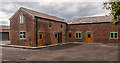
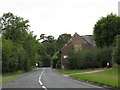
Castle Hill Farm
Castle Hill Farm on Mill Lane.
Image: © Peter McDermott
Taken: 16 Aug 2014
0.01 miles

4
Sheep near Castle Hill Farm adjoining Manchester Airport
Image: © Richard Humphrey
Taken: 19 Nov 2018
0.04 miles
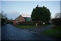
6
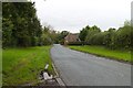
Wayside Farm
An appositely named farm on the lane to Ashley.
Image: © Peter Whatley
Taken: 17 Sep 2009
0.07 miles
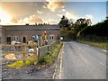
9
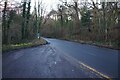
Castle Hill
The old road at Castle Hill.
Image: © Peter McDermott
Taken: 16 Aug 2014
0.10 miles
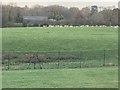
10
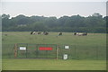
Cows at Castle Hill Farm
They are unperturbed by the planes nearby, as their field adjoins Manchester Airport. The fence marks the edge of the airport.
Image: © Bill Boaden
Taken: 11 Aug 2012
0.15 miles