IMAGES TAKEN NEAR TO
Castle Mill Lane, ALTRINCHAM, WA15 0QT
Introduction
This page details the photographs taken nearby to Castle Mill Lane, WA15 0QT by members of the Geograph project.
The Geograph project started in 2005 with the aim of publishing, organising and preserving representative images for every square kilometre of Great Britain, Ireland and the Isle of Man.

There are currently over 7.5m images from over14,400 individuals and you can help contribute to the project by visiting https://www.geograph.org.uk
Image Map
Images are licensed for reuse under creativecommons.org/licenses/by-sa/2.0
Notes
- Clicking on the map will re-center to the selected point.
- The higher the marker number, the further away the image location is from the centre of the postcode.
Image Listing (8 Images Found)
Images are licensed for reuse under creativecommons.org/licenses/by-sa/2.0
Image
Details
Distance
1
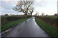
Old Direction Sign - Signpost by Tanyard Lane junction with Castle Mill Lane
Pawn finial - 3 arms; Cheshire New CCC octagonal by the UC road, in parish of Ashley (Macclesfield District), Tanyard Lane junction, East of Tanyard Farm, .
Surveyed
Milestone Society National ID: CH_SJ7884.
Image: © Milestone Society
Taken: Unknown
0.05 miles
2
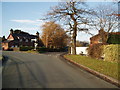
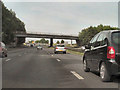
Castle Mill Lane
Taken on Castle Mill Lane, looking NW. The lane actually continues to the right and crosses the M56, to the left is Tanyard Lane.
Image: © Ian Warburton
Taken: 11 Dec 2005
0.11 miles
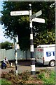
7
Junction of Back Lane and Tanyard Lane, Ashley
Former Ashley village school in the distance.
Image: © Anthony O'Neil
Taken: 25 Mar 2011
0.21 miles