IMAGES TAKEN NEAR TO
Sunbank Lane, ALTRINCHAM, WA15 0PS
Introduction
This page details the photographs taken nearby to Sunbank Lane, WA15 0PS by members of the Geograph project.
The Geograph project started in 2005 with the aim of publishing, organising and preserving representative images for every square kilometre of Great Britain, Ireland and the Isle of Man.

There are currently over 7.5m images from over14,400 individuals and you can help contribute to the project by visiting https://www.geograph.org.uk
Image Map
Images are licensed for reuse under creativecommons.org/licenses/by-sa/2.0
Notes
- Clicking on the map will re-center to the selected point.
- The higher the marker number, the further away the image location is from the centre of the postcode.
Image Listing (52 Images Found)
Images are licensed for reuse under creativecommons.org/licenses/by-sa/2.0
Image
Details
Distance
1
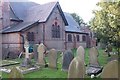
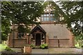
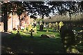
Abandoned?
The graveyard and former Parish Church of Ringway, now only 50 metres from the rapidly extending southern fringe of Manchester Airport.
Image: © Anthony O'Neil
Taken: 22 Mar 2020
0.00 miles
2
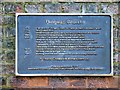
Ringway Church - Information Plaque
Plaque attached to the wall of Image
Ringway Church
1515 First record of 'Ringway Chapel'; a chapel of ease in Bowden Parish.
1720 New chapel built.
1721 Dissenting worshippers were forcibly ejected from the chapel.
1895 20th April. The present building was consecrated.
Designed by Architects Preston & Vaughan of Manchester.
Built by William Brown and Son of Salford at a cost of £3000.
Financed by Wilbraham Baron Egerton of Tatton
Dedication to St Mary added in Memory of Baron Egerton's first wife.
1970 Church closed after new Parish Church built in Hale Barns.
Building used as a storeroom.
1997 Building restored and converted for use as a design studio by:
Richard Chadwick Associates Ltd
Plaque placed here in 1997
Dedicated to God's Glory and Fred Ratcliffe 'Pa' of Ringway. 1913-1984
Image: © David Dixon
Taken: 7 Nov 2013
0.01 miles
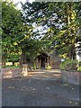
3
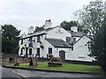
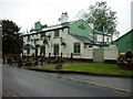
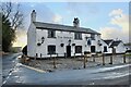
The Romper Pub & Restaurant
Chef & Brewer owned public house and restaurant, somewhat tucked away on a now minor road serving the airport viewing area and adjacent business units.
Image: © David Robinson
Taken: 6 Jul 2019
0.01 miles
5
Ringway Church, Sunbank Lane
The first records referring to a ‘Ringway Chapel’ date from 1515 when it was recorded as a chapel of ease in Bowden Parish. The present building, which was consecrated in 1895, closed as a church in 1970 and was used as a storeroom after a new parish church had been built in Hale Barns.
In 1997, the building was restored and converted for use as a design studio by Richard Chadwick Design Ltd.
Image]
Image: © David Dixon
Taken: 7 Nov 2013
0.01 miles
6
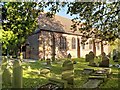
Ringway Church (St Mary's)
The first records referring to a ‘Ringway Chapel’ date from 1515 when it was recorded as a chapel of ease in Bowden Parish. The present building, which was consecrated in 1895, closed as a church in 1970 and was used as a storeroom after a new parish church had been built in Hale Barns.
In 1997, the building was restored and converted for use as a design studio by Richard Chadwick Associates Ltd.
Image]
Image: © David Dixon
Taken: 7 Nov 2013
0.01 miles
8
Back in business
The historic Romper pub has survived the Virus and is open to customers.
Image: © Anthony O'Neil
Taken: 10 Feb 2022
0.02 miles
9
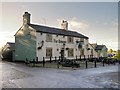
The Romper Pub/Restaurant, Wilmslow Old Road
Image: © David Dixon
Taken: 7 Nov 2013
0.02 miles