IMAGES TAKEN NEAR TO
Wyngate Road, ALTRINCHAM, WA15 0LZ
Introduction
This page details the photographs taken nearby to Wyngate Road, WA15 0LZ by members of the Geograph project.
The Geograph project started in 2005 with the aim of publishing, organising and preserving representative images for every square kilometre of Great Britain, Ireland and the Isle of Man.

There are currently over 7.5m images from over14,400 individuals and you can help contribute to the project by visiting https://www.geograph.org.uk
Image Map
Images are licensed for reuse under creativecommons.org/licenses/by-sa/2.0
Notes
- Clicking on the map will re-center to the selected point.
- The higher the marker number, the further away the image location is from the centre of the postcode.
Image Listing (17 Images Found)
Images are licensed for reuse under creativecommons.org/licenses/by-sa/2.0
Image
Details
Distance
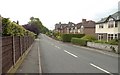
1
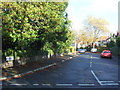
Wyngate Road, Hale
Looking north from Bankhall Lane.
Image: © JThomas
Taken: 5 Nov 2016
0.02 miles
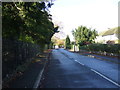
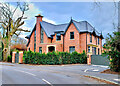
4
Bankhall Lane, approaching the railway bridge, Hale
Rail line from Manchester/Stockport to Chester.
Image: © Anthony O'Neil
Taken: 19 Jun 2010
0.11 miles
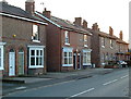
7
Greengrocer's at Park Road, Hale, Trafford
Image: © Anthony O'Neil
Taken: 28 Jan 2011
0.16 miles
8
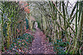
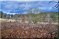
Path to the Bollin
From Bankhall Lane, Hale
Image: © Anthony O'Neil
Taken: 27 Feb 2023
0.16 miles
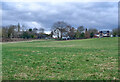
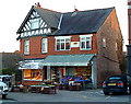
9
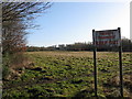
Keep Out!
Welcoming sign at the side of Bankhall Lane, Hale.
Image: © Peter Whatley
Taken: 20 Jan 2009
0.19 miles