IMAGES TAKEN NEAR TO
Wicker Lane, ALTRINCHAM, WA15 0HG
Introduction
This page details the photographs taken nearby to Wicker Lane, WA15 0HG by members of the Geograph project.
The Geograph project started in 2005 with the aim of publishing, organising and preserving representative images for every square kilometre of Great Britain, Ireland and the Isle of Man.

There are currently over 7.5m images from over14,400 individuals and you can help contribute to the project by visiting https://www.geograph.org.uk
Image Map
Images are licensed for reuse under creativecommons.org/licenses/by-sa/2.0
Notes
- Clicking on the map will re-center to the selected point.
- The higher the marker number, the further away the image location is from the centre of the postcode.
Image Listing (256 Images Found)
Images are licensed for reuse under creativecommons.org/licenses/by-sa/2.0
Image
Details
Distance
2
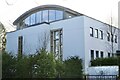
Shaare Sedek synagogue, Hale Barns
One of four places of worship within a few hundred yards of the village centre:
another synagogue, a Catholic church, an Anglican church; and a Muslim Association, within two miles. Hale Barns would appear to be a melting pot of religious faiths.
Image: © Anthony O'Neil
Taken: 25 Mar 2020
0.02 miles
3

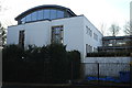
Shaare Hayim Synagogue
Wicker Lane, Hale Barns
Image: © Anthony O'Neil
Taken: 13 Feb 2023
0.03 miles
4
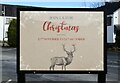
Too late or too soon!
Hotel sign, Hale Barns: 24 March 2021
Image: © Anthony O'Neil
Taken: 24 Mar 2021
0.03 miles
5
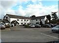
Hotel, Hale Barns
Created in the grounds of the old Bulls Head pub, Hale Barns, and offering 3* accommodation. 18th century records seem to indicate that, in those days, the pub was on the other (West) side of Wicker Lane, opposite this hotel.
Image: © Anthony O'Neil
Taken: 6 Mar 2016
0.03 miles
6
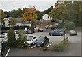
Construction site, Wicker Lane
Building work opposite the car park of the Bull's Head on Wicker Lane, Hale Barns. The photograph was taken from the upper floor of the Lodge - the bedrooms associated with the Bull's Head.
Image: © Richard Sutcliffe
Taken: 18 Oct 2015
0.03 miles
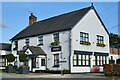
7
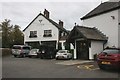
The Bull's Head, Hale Barns
The Bull's Head is on the left of the photograph. The porch on the right is the entrance to the Lodge - the bedroom accommodation associated with the pub.
Image: © Richard Sutcliffe
Taken: 18 Oct 2015
0.04 miles
8
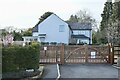
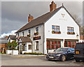
Detached house
Wicker Lane, Hale Barns
Image: © Anthony O'Neil
Taken: 24 Mar 2021
0.04 miles
9
The Bulls Head, Hale Barns
(Note: no apostrophe in the current form of the name.) In the 19th century, this village pub stood to the left, at the other side of Wicker Lane, on land now occupied by St Ambrose Prep School.
Image: © Anthony O'Neil
Taken: 6 Mar 2016
0.05 miles