IMAGES TAKEN NEAR TO
The Paddocks, ALTRINCHAM, WA15 0HA
Introduction
This page details the photographs taken nearby to The Paddocks, WA15 0HA by members of the Geograph project.
The Geograph project started in 2005 with the aim of publishing, organising and preserving representative images for every square kilometre of Great Britain, Ireland and the Isle of Man.

There are currently over 7.5m images from over14,400 individuals and you can help contribute to the project by visiting https://www.geograph.org.uk
Image Map
Images are licensed for reuse under creativecommons.org/licenses/by-sa/2.0
Notes
- Clicking on the map will re-center to the selected point.
- The higher the marker number, the further away the image location is from the centre of the postcode.
Image Listing (273 Images Found)
Images are licensed for reuse under creativecommons.org/licenses/by-sa/2.0
Image
Details
Distance
1
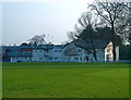
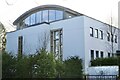
Original building of St Ambrose College, Hale Barns
Established after World War ll, the school and its resident Christian Brothers started here, in a former private mansion, and steadily expanded to other parts of the extensive grounds.
Image: © Anthony O'Neil
Taken: 28 Mar 2011
0.04 miles
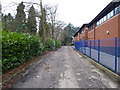
2
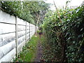
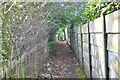
Footpath leading to Wicker Lane
Over the fence to the left is St Ambrose Preparatory School; over the fence to the right is Hale Barns Vicarage.
Image: © Anthony O'Neil
Taken: 13 Jan 2013
0.04 miles
3
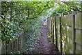
Public footpath (1)
Alongside St Ambrose College grounds
Image: © Anthony O'Neil
Taken: 24 Mar 2021
0.05 miles
4
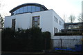
Shaare Sedek synagogue, Hale Barns
One of four places of worship within a few hundred yards of the village centre:
another synagogue, a Catholic church, an Anglican church; and a Muslim Association, within two miles. Hale Barns would appear to be a melting pot of religious faiths.
Image: © Anthony O'Neil
Taken: 25 Mar 2020
0.05 miles
7
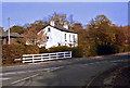
Wicker Lane, Hale Barns
Junction with Chapel Lane
Image: © Anthony O'Neil
Taken: Unknown
0.05 miles
8
Detached house
Wicker Lane, Hale Barns
Image: © Anthony O'Neil
Taken: 24 Mar 2021
0.05 miles
9
Former front driveway of 'Woodeaves'
When the home (built 1915) of the Waugh family was first sold to the Christian Brothers in 1945, this was an imposing tree-lined entrance drive with an ornamental woodland ahead, and a pond on the right (now a Prep School) separating the drive from the outbuildings of a Victorian Manor - the ruins of which stood where Holy Angels RC church now is.
Image: © Anthony O'Neil
Taken: 13 Jan 2013
0.05 miles
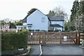
10

Shaare Hayim Synagogue
Wicker Lane, Hale Barns
Image: © Anthony O'Neil
Taken: 13 Feb 2023
0.05 miles