IMAGES TAKEN NEAR TO
Broad Lane, ALTRINCHAM, WA15 0DE
Introduction
This page details the photographs taken nearby to Broad Lane, WA15 0DE by members of the Geograph project.
The Geograph project started in 2005 with the aim of publishing, organising and preserving representative images for every square kilometre of Great Britain, Ireland and the Isle of Man.

There are currently over 7.5m images from over14,400 individuals and you can help contribute to the project by visiting https://www.geograph.org.uk
Image Map
Images are licensed for reuse under creativecommons.org/licenses/by-sa/2.0
Notes
- Clicking on the map will re-center to the selected point.
- The higher the marker number, the further away the image location is from the centre of the postcode.
Image Listing (136 Images Found)
Images are licensed for reuse under creativecommons.org/licenses/by-sa/2.0
Image
Details
Distance
1
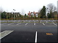
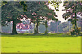
College car park
At the rear of the newly completed St Ambrose buildings. It borders Broad Lane whose mansions can be seen in the distance. Among previous residents of Broad Lane was the Liberal peer, and broadcaster, Michael (Lord) Winstanley. The area contains many multi-million pound properties in spacious gardens.
Image: © Anthony O'Neil
Taken: 13 Jan 2013
0.03 miles
2
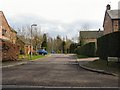
Ashmeade
Cul-de-Sac of imposing houses behind St.Ambrose's College.
Image: © Roger May
Taken: 29 Mar 2006
0.05 miles
3
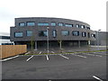
Side elevation of St Ambrose, Hale Barns
Image: © Anthony O'Neil
Taken: 13 Jan 2013
0.08 miles
4
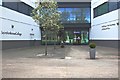
College Entrance
From Hale Road. Edmund Ignacius Rice (1762 - 1844) was the founder of the Irish Christian Brothers whose Order started St Ambrose in Hale Barns in 1946.
These new buildings are a far cry from the make-shift classrooms where 300 boys were housed in a former country house ('Woodeaves') the 1950s.
Image: © Anthony O'Neil
Taken: 28 Mar 2020
0.08 miles
5
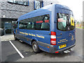
Luxury transport for College boys
Mercedes minibus parked outside the new College buildings.
Image: © Anthony O'Neil
Taken: 13 Jan 2013
0.08 miles
6
St Ambrose College (9)
View across the northern playing fields. In the 1950s, the College had not developed this area of the grounds and it was still given over to the growing of potatoes and root vegetables. Indeed, the boys of the school were sometimes dragooned into helping harvest the crops.
The land runs down to Broad Lane, an avenue of large detached properties, like the one in the photo, amongst which was the home of the Liberal peer, Lord Winstanley.
Image: © Anthony O'Neil
Taken: Unknown
0.08 miles
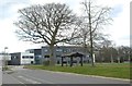
7

Hale Road passing Halecroft Park
Another good display of autumn colour.
Image: © Bill Boaden
Taken: 11 Nov 2017
0.08 miles
8

Building site entrance to St Ambrose College from Hale Road
Mature trees were removed to make way for earth moving equipment at the site of the St Ambrose development project.
Image: © Anthony O'Neil
Taken: 28 Mar 2011
0.08 miles
9
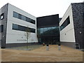
Front entrance, St Ambrose
Completed as part of a multi-million pound development plan.
Image: © Anthony O'Neil
Taken: 13 Jan 2013
0.08 miles
10
St Ambrose College, Hale Barns
The new campus of this leading Catholic grammar school was created at the end of the old playing fields, adjacent to Hale Road. To the left (unseen) are extensive additional sporting facilities.
Image: © Anthony O'Neil
Taken: 28 Mar 2020
0.09 miles