IMAGES TAKEN NEAR TO
Millway, ALTRINCHAM, WA15 0AE
Introduction
This page details the photographs taken nearby to Millway, WA15 0AE by members of the Geograph project.
The Geograph project started in 2005 with the aim of publishing, organising and preserving representative images for every square kilometre of Great Britain, Ireland and the Isle of Man.

There are currently over 7.5m images from over14,400 individuals and you can help contribute to the project by visiting https://www.geograph.org.uk
Image Map
Images are licensed for reuse under creativecommons.org/licenses/by-sa/2.0
Notes
- Clicking on the map will re-center to the selected point.
- The higher the marker number, the further away the image location is from the centre of the postcode.
Image Listing (26 Images Found)
Images are licensed for reuse under creativecommons.org/licenses/by-sa/2.0
Image
Details
Distance
1
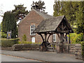
Hale Chapel
The Unitarian Chapel on Chapel Lane, Hale Barns was built in 1723 and was originally a Presbyterian meeting house. It is a Grade II listed building.
Image: © David Dixon
Taken: 16 Sep 2011
0.07 miles
2
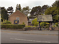
Hale Chapel
The Unitarian Chapel on Chapel Lane, Hale Barns, was built in 1723 and was originally a Presbyterian meeting house. It is a Grade II listed building.
Image: © David Dixon
Taken: 16 Sep 2011
0.07 miles

4
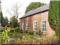
Hale Chapel
The Unitarian Chapel at Hale, of which this is the south wall, was opened in 1723. You attention is drawn to the sundial over one of the windows.
Image: © Roger May
Taken: 15 Nov 2005
0.08 miles
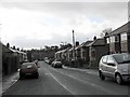
5
Hale - High Elm Road
Taken from the southern end of Elmridge Drive.
Image: © Peter Whatley
Taken: 23 Jan 2009
0.14 miles

9
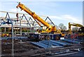
Hale Barns reconstructed
Heavy plant at work on the site of the new shopping centre.
Image: © Anthony O'Neil
Taken: 7 Mar 2014
0.19 miles
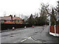
10
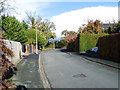
Winmarith Drive, Hale Barns
Approaching the junction with Hale Road. The drive takes its name from a large, pre-war villa which stood in grounds to the right of the photograph. 'Winmarith' is shown on the 1940 local, large-scale plan but, in the following decades, was demolished to make way for the present incumbent - a block of luxury apartments called "The Greens" - which was not an improvement, aesthetically, over its predecessor.
Image: © Anthony O'Neil
Taken: 9 Nov 2013
0.19 miles