IMAGES TAKEN NEAR TO
Kingsland Grange, WARRINGTON, WA1 4RW
Introduction
This page details the photographs taken nearby to Kingsland Grange, WA1 4RW by members of the Geograph project.
The Geograph project started in 2005 with the aim of publishing, organising and preserving representative images for every square kilometre of Great Britain, Ireland and the Isle of Man.

There are currently over 7.5m images from over14,400 individuals and you can help contribute to the project by visiting https://www.geograph.org.uk
Image Map
Images are licensed for reuse under creativecommons.org/licenses/by-sa/2.0
Notes
- Clicking on the map will re-center to the selected point.
- The higher the marker number, the further away the image location is from the centre of the postcode.
Image Listing (7 Images Found)
Images are licensed for reuse under creativecommons.org/licenses/by-sa/2.0
Image
Details
Distance
1
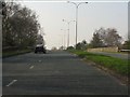
B5210 about to cross the Cheshire Lines railway
Image: © Peter Whatley
Taken: 24 Mar 2011
0.14 miles
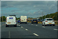
4
Birchwood : M6 Motorway
The M6 between Junction 21A (Croft Interchange) and Junction 21.
Image: © Lewis Clarke
Taken: 27 Sep 2019
0.17 miles
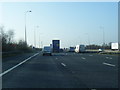
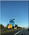
5
Woolston : M6 Motorway
The M6 Motorway between Junction 21 and Junction 21A (Croft Interchange).
Image: © Lewis Clarke
Taken: 23 Sep 2019
0.17 miles
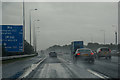
7
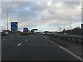
M6 Motorway crossing the Cheshire Lines railway
Two lines on the carriageway reveal the location of the bridge over the Warrington Central to Manchester railway line, once the pride of the Cheshire Lines Committee joint railway company. The sign on the left indicates the imminence of the junctions for the M62, first westbound and, a half-mile later, eastbound.
Image: © Peter Whatley
Taken: 18 Jan 2011
0.22 miles