IMAGES TAKEN NEAR TO
Mancroft Close, WARRINGTON, WA1 4DH
Introduction
This page details the photographs taken nearby to Mancroft Close, WA1 4DH by members of the Geograph project.
The Geograph project started in 2005 with the aim of publishing, organising and preserving representative images for every square kilometre of Great Britain, Ireland and the Isle of Man.

There are currently over 7.5m images from over14,400 individuals and you can help contribute to the project by visiting https://www.geograph.org.uk
Image Map
Images are licensed for reuse under creativecommons.org/licenses/by-sa/2.0
Notes
- Clicking on the map will re-center to the selected point.
- The higher the marker number, the further away the image location is from the centre of the postcode.
Image Listing (3 Images Found)
Images are licensed for reuse under creativecommons.org/licenses/by-sa/2.0
Image
Details
Distance
1
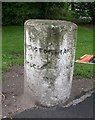
Old Milestone by the A57, Manchester Road, Woolston
Carved stone post by the A57, in parish of WOOLSTON (WARRINGTON District), Manchester Road junction with Redwood Close on verge, on South side of road. Warrington flat top erected by the Warrington & Lower Irlam turnpike trust in the 19th century.
Inscription reads:-
: TO / WARRINGTON / 3 / MILES : : TO / MANCHESTER / 16 / MILES :
Grade II listed.
List Entry Number: 1392453 https://historicengland.org.uk/listing/the-list/list-entry/1392453
Milestone Society National ID: LA_WAMA03
Image: © M Faherty
Taken: 24 Aug 2008
0.13 miles
2
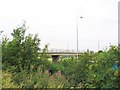
M6 Bridge
This bridge provides access to Moss Farm on Woolston Moss.
Image: © Dave Smethurst
Taken: 14 Jul 2005
0.20 miles
3
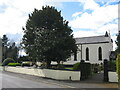
St Peter's Church, Martinscroft
St Peter's RC Church in Weir Lane, Martinscroft was opened in 1835. Martinscroft, within the ancient manor of Woolston, was once home to the Mersey fishermen as the river had many fish at that time.
Image: © Sue Adair
Taken: 1 Apr 2022
0.23 miles