IMAGES TAKEN NEAR TO
Henshall Lane, ALTRINCHAM, WA14 5SL
Introduction
This page details the photographs taken nearby to Henshall Lane, WA14 5SL by members of the Geograph project.
The Geograph project started in 2005 with the aim of publishing, organising and preserving representative images for every square kilometre of Great Britain, Ireland and the Isle of Man.

There are currently over 7.5m images from over14,400 individuals and you can help contribute to the project by visiting https://www.geograph.org.uk
Image Map
Images are licensed for reuse under creativecommons.org/licenses/by-sa/2.0
Notes
- Clicking on the map will re-center to the selected point.
- The higher the marker number, the further away the image location is from the centre of the postcode.
Image Listing (12 Images Found)
Images are licensed for reuse under creativecommons.org/licenses/by-sa/2.0
Image
Details
Distance
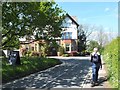
1
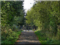
Trans Pennine Trail
The Trans Pennine Trail, approaching Station Road Dunham Woodhouses.
Image: © David Dixon
Taken: 1 Oct 2011
0.11 miles
3
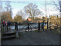
Trans Pennine Path, Station Road
The Trans Pennine Path, about to cross Station Road, Dunham Woodhouses.
Image: © David Dixon
Taken: 1 Oct 2011
0.13 miles
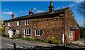
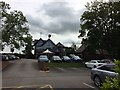
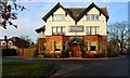
5
The Rope and Anchor, Station Road, Dunham Massey
Image: © Gary Rogers
Taken: 15 May 2016
0.15 miles
6
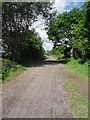
Trans-Pennine Trail - Dunham Woodhouses
Image: © Anthony Parkes
Taken: 30 May 2010
0.17 miles
7
The Rope and Anchor
Another serious recommendation for foodies!
Image: © Ian Greig
Taken: 11 Sep 2014
0.18 miles
8
Back of the Rope & Anchor Pub, Dunham Massey
Image: © Richard Cooke
Taken: 6 Jul 2019
0.18 miles
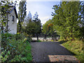
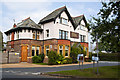
10
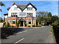
Rope & Anchor
The Rope and Anchor at the junction of Station Road and Paddock Lane, Dunham Woodhouses.
Image: © David Dixon
Taken: 1 Oct 2011
0.19 miles