IMAGES TAKEN NEAR TO
School Lane, ALTRINCHAM, WA14 5RN
Introduction
This page details the photographs taken nearby to School Lane, WA14 5RN by members of the Geograph project.
The Geograph project started in 2005 with the aim of publishing, organising and preserving representative images for every square kilometre of Great Britain, Ireland and the Isle of Man.

There are currently over 7.5m images from over14,400 individuals and you can help contribute to the project by visiting https://www.geograph.org.uk
Image Map
Images are licensed for reuse under creativecommons.org/licenses/by-sa/2.0
Notes
- Clicking on the map will re-center to the selected point.
- The higher the marker number, the further away the image location is from the centre of the postcode.
Image Listing (7 Images Found)
Images are licensed for reuse under creativecommons.org/licenses/by-sa/2.0
Image
Details
Distance
2
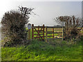
Gate
The gate allows permissive access to the farmland. Two DEFRA notices on either side explain the conditions for allowing access to the field.
Image: © David Dixon
Taken: 22 Mar 2012
0.21 miles
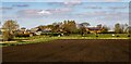
3
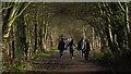
Footpath parallel to the Transpennine Way
The carved wood fingerpost suggested this was heading to the Bollin Valley? It seems to be going in totally the wrong direction.
Image: © Ian Greig
Taken: 17 Apr 2015
0.21 miles
4
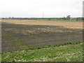
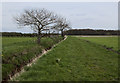
Very Flat, Cheshire
A monotonous vista of fields, typical of the Cheshire Plain.
Image: © Peter Whatley
Taken: 31 Mar 2009
0.21 miles
6
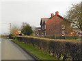
Black Brow Farm
Black Brow Farm, on Black Moss Lane.
Image: © David Dixon
Taken: 22 Mar 2012
0.23 miles