IMAGES TAKEN NEAR TO
Ocean Street, ALTRINCHAM, WA14 5QL
Introduction
This page details the photographs taken nearby to Ocean Street, WA14 5QL by members of the Geograph project.
The Geograph project started in 2005 with the aim of publishing, organising and preserving representative images for every square kilometre of Great Britain, Ireland and the Isle of Man.

There are currently over 7.5m images from over14,400 individuals and you can help contribute to the project by visiting https://www.geograph.org.uk
Image Map
Images are licensed for reuse under creativecommons.org/licenses/by-sa/2.0
Notes
- Clicking on the map will re-center to the selected point.
- The higher the marker number, the further away the image location is from the centre of the postcode.
Image Listing (20 Images Found)
Images are licensed for reuse under creativecommons.org/licenses/by-sa/2.0
Image
Details
Distance
1
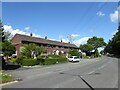
Terrace housing on Dairyhouse Lane
Dairyhouse Lane is used by the Trans Pennine Trail and behind the camera is the route of the former Warrington & Stockport railway line.
Image: © Kevin Waterhouse
Taken: 9 Aug 2024
0.11 miles
2
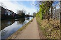
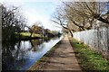
Bridgewater Canal towards Seaman's Moss Bridge
Image: © Ian S
Taken: 1 Mar 2022
0.16 miles
3
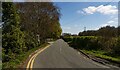
Dairyhouse Lane
Dairyhouse Lane, part of the Trans Pennine Trail.
Image: © Peter McDermott
Taken: 2 Apr 2021
0.17 miles
4
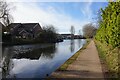
Bridgewater Canal
Looking eastwards, along the Bridgewater Canal between Oldfield Brow and Broadheath.
Image: © David Dixon
Taken: 14 Jan 2012
0.17 miles
5
Bridgewater Canal towards Seaman's Moss Bridge
Image: © Ian S
Taken: 1 Mar 2022
0.17 miles
6
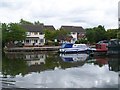
Marina and canalside housing, Bridgewater Canal
Image: © David Martin
Taken: 1 Aug 2010
0.17 miles
7
Bridgewater Canal towards Seamon's Moss Bridge
Image: © Ian S
Taken: 1 Mar 2022
0.18 miles
8
Bridgewater Canal
A view of the crane situated on the bank of the Bridgewater Canal at Broadheath.
Image: © Alan Edwards
Taken: 26 Dec 2004
0.19 miles
9
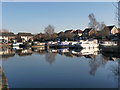
Marina at Oldfield Brow
The Marina at Oldfield Brow, on the Bridgewater canal.
Image: © David Dixon
Taken: 14 Jan 2012
0.19 miles
10
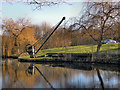
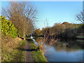
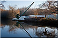
Crane and Boards, Bridgewater Canal
During its history, The Bridgewater Canal has suffered three breaches. One occurred soon after opening, another in 1971 near the River Bollin aqueduct, and another in the summer of 2005 when a sluice gate failed in Manchester.
Cranes are located at intervals along the canal's length to allow boards to be dropped into slots in the banks. These allow sections of the canal to be isolated in the event of a leak. This one is near Oldfield Brow.
Image: © David Dixon
Taken: 14 Jan 2012
0.19 miles