IMAGES TAKEN NEAR TO
Atlantic Street, ALTRINCHAM, WA14 5GZ
Introduction
This page details the photographs taken nearby to Atlantic Street, WA14 5GZ by members of the Geograph project.
The Geograph project started in 2005 with the aim of publishing, organising and preserving representative images for every square kilometre of Great Britain, Ireland and the Isle of Man.

There are currently over 7.5m images from over14,400 individuals and you can help contribute to the project by visiting https://www.geograph.org.uk
Image Map
Images are licensed for reuse under creativecommons.org/licenses/by-sa/2.0
Notes
- Clicking on the map will re-center to the selected point.
- The higher the marker number, the further away the image location is from the centre of the postcode.
Image Listing (29 Images Found)
Images are licensed for reuse under creativecommons.org/licenses/by-sa/2.0
Image
Details
Distance
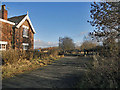
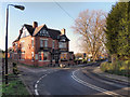
2
Start of Trans Pennine Trail on former railway
The trail starts at a former road level crossing now known as Cinderland Crossing. The cross keeper's house stands by the side of the former Warrington & Stockport railway line.
Image: © Kevin Waterhouse
Taken: 9 Aug 2024
0.06 miles
3
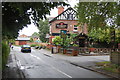
The Bay Malton
A pub, and Thai and Chinese Restaurant - very handy for users of the Bridgewater Canal.
Image: © Trevor Harris
Taken: 8 Jun 2012
0.13 miles
4
The Bay Malton
The Bay Malton public house, undergoing major refurbishment.
Image: © Peter McDermott
Taken: 2 Apr 2021
0.13 miles
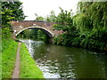
5
Bay Malton
The Bay Malton public house on Seamon's Road, near Seamon's Moss Bridge on the Bridgewater Canal.
Image: © David Dixon
Taken: 14 Jan 2012
0.13 miles
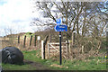
6

Alternative tracks
Beside the Trans Pennine Trail waymarks this sign indicates other routes available to walkers and riders.
Image: © David Long
Taken: 3 Apr 2006
0.14 miles
7
Diversionary tactics
The Trans Pennine Trail follows the abandoned railway line from Warrington to Altrincham for many miles - but has to divert drastically away from it at Broadheath and take to the roads.
Image: © David Long
Taken: 3 Apr 2006
0.14 miles
8

Canalside housing, off Seamon's Road
On the north bank of the Bridgewater Canal, at the western edge of Altrincham.
Image: © Christine Johnstone
Taken: 22 May 2021
0.14 miles
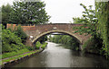
10
Seamons Moss Bridge, Bridgewater Canal
Image: © John H Darch
Taken: 7 Sep 2012
0.14 miles