IMAGES TAKEN NEAR TO
Dunham Road, ALTRINCHAM, WA14 4QD
Introduction
This page details the photographs taken nearby to Dunham Road, WA14 4QD by members of the Geograph project.
The Geograph project started in 2005 with the aim of publishing, organising and preserving representative images for every square kilometre of Great Britain, Ireland and the Isle of Man.

There are currently over 7.5m images from over14,400 individuals and you can help contribute to the project by visiting https://www.geograph.org.uk
Image Map
Images are licensed for reuse under creativecommons.org/licenses/by-sa/2.0
Notes
- Clicking on the map will re-center to the selected point.
- The higher the marker number, the further away the image location is from the centre of the postcode.
Image Listing (38 Images Found)
Images are licensed for reuse under creativecommons.org/licenses/by-sa/2.0
Image
Details
Distance
1
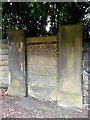
Carved stonework, Hilston House
In the garden wall of a house at the western end of Green Walk.
Image: © Richard Sutcliffe
Taken: 23 Apr 2017
0.05 miles
2
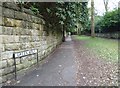
Bowdon footpath
Leading from the busy Dunham Road, Altrincham
Image: © Anthony O'Neil
Taken: 2 Apr 2020
0.07 miles
3
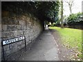
Green Walk
This part of Green Walk lives up to its name, as it is a pedestrian path only at this point, before widening out to be a road further on.
Image: © Richard Sutcliffe
Taken: 23 Apr 2017
0.07 miles
4
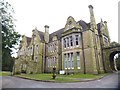
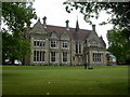
Denzell House, Bowdon
View from the entrance drive. Once the suburban retreat of a wealthy textile manufacturer. It was built in 1874 (by Robert Scott), and the subsequent owner (Samuel Lamb) extended the surrounding land into landscaped gardens and tennis courts. These, in turn, were acquired by the local Council and opened to the public in the 1930s. At one time, the house was used as a convalescent home for patients from Altrincham Hospital.
Image: © Anthony O'Neil
Taken: 2 Apr 2020
0.07 miles
5
Altrincham, Denzell House
Substantial Victorian house, built in 1874 for industrialist Robert Scott; the surrounding gardens are owned by Trafford Council and open to the public (Image), but the house is in private possession. http://www.trafford.gov.uk/content/tca/display_image.asp?ImageID=867
Image: © Mike Faherty
Taken: 18 May 2009
0.08 miles
6
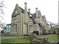
Denzell House (rear)
Bowdon, Cheshire
Image: © Anthony O'Neil
Taken: 2 Apr 2020
0.09 miles
7
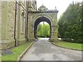
Porte-cochere at Denzell House
A porte-cochere is a carriage porch a covered porch-like structure at a main or secondary entrance to a building through which originally a horse and carriage and today a motor vehicle can pass to provide arriving and departing occupants protection from the elements.
Image: © Eirian Evans
Taken: 10 May 2015
0.09 miles
9
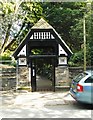
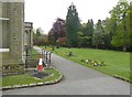
Entrance to Denzell Gardens
Off Green Walk. The gardens are managed by Trafford Metropolitan Borough Council.
Image: © Richard Sutcliffe
Taken: 23 Apr 2017
0.13 miles
10
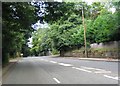
A556
This is the view from SJ752872 looking NE along the A556 heading towards Altrincham.
Image: © Dave Smethurst
Taken: 28 Aug 2005
0.13 miles