IMAGES TAKEN NEAR TO
Oldfield Road, ALTRINCHAM, WA14 4JA
Introduction
This page details the photographs taken nearby to Oldfield Road, WA14 4JA by members of the Geograph project.
The Geograph project started in 2005 with the aim of publishing, organising and preserving representative images for every square kilometre of Great Britain, Ireland and the Isle of Man.

There are currently over 7.5m images from over14,400 individuals and you can help contribute to the project by visiting https://www.geograph.org.uk
Image Map (7 Images)


Getting Data...Please wait
Leaflet Map data © OpenStreetMap
Images are licensed for reuse under creativecommons.org/licenses/by-sa/2.0
Notes
- Clicking on the map will re-center to the selected point.
- The higher the marker number, the further away the image location is from the centre of the postcode.
Image Listing (7 Images Found)
Images are licensed for reuse under creativecommons.org/licenses/by-sa/2.0
Image
Details
Distance
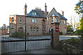
1
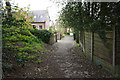
Cobbled path down to Oldfield Road
A longstanding route which is now a back path.
Image: © Bill Boaden
Taken: 2 May 2015
0.05 miles
2
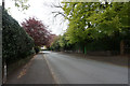
Bonville Road
A leafy road near Altrincham. The land rises a little here allowing views to the north, if only there was a bit of open land to see them.
Image: © Bill Boaden
Taken: 2 May 2015
0.12 miles
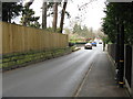
4
Bradgate Road, Altrincham
From close to the junction with Bonville Road, looking along an avenue of tall trees.
Image: © Derek Harper
Taken: 18 Aug 2010
0.24 miles
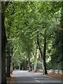
6
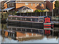
J-Peg
A narrowboat moored on the Bridgewater Canal at Oldfield Brow.
Image: © David Dixon
Taken: 14 Jan 2012
0.24 miles
7
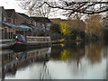
Bridgewater Canal, Oldfield Brow
A narrowboat moored on the Bridgewater Canal at Oldfield Brow.
Image: © David Dixon
Taken: 14 Jan 2012
0.25 miles