1
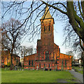
St Georges Church
This image was taken from SJ767882 looking WSW towards St Georges Church, Altrincham.
Image: © Dave Smethurst
Taken: 28 Aug 2005
0.10 miles
2
St George's Parish church
St George's Church, Altrincham, is a Grade II listed building. It was originally built in 1799. The tower and spire date from 1874 and the chancel from 1886. In 1896–97 the nave was rebuilt.
http://en.wikipedia.org/wiki/St_George's_Church,_Altrincham - more informatikon (Wikipedia article)
Image: © David Dixon
Taken: 12 Jan 2012
0.12 miles
3
St George's Church, Altrincham
View of the front of the church http://www.stgeorgesaltrincham.org/ taken from a handy hotel window.
Image: © Ian Paterson
Taken: 15 Feb 2011
0.12 miles
4
Church Street in Altrincham, Trafford
This is the A56 Church Street, looking south-east near the junction with Oldfield Road.
Image: © Roger D Kidd
Taken: 18 May 2017
0.12 miles
5
Church Street in Altrincham, Trafford
Looking south-east along the north bound carriageway of the A56 Church Street in Altrincham.
Image: © Roger D Kidd
Taken: 18 May 2017
0.12 miles
6
Church of St George and Altrincham rooftops
View from the ninth floor of Altrincham Central Travelodge. The tower and spire of Grade II listed Church of England Church of St George rises above the other rooftops.
Image: © Richard Sutcliffe
Taken: 26 Mar 2017
0.12 miles
7
St George's Church, Altrincham
St George's Church, Altrincham, is a Grade II listed building. It was originally built in 1799. The tower and spire date from 1874 and the chancel from 1886. In 1896–97 the nave was rebuilt.
http://en.wikipedia.org/wiki/St_George's_Church,_Altrincham - more informatikon (Wikipedia article)
Image: © David Dixon
Taken: 12 Jan 2012
0.12 miles
8
Catholic girls' Prep. school
On Dunham Road, next door but one to the Convent.
Image: © Anthony O'Neil
Taken: 7 Nov 2013
0.15 miles
9
Oldfield Road in Altrincham, Trafford
Looking east towards Manchester Road (A56).
Image: © Roger D Kidd
Taken: 18 May 2017
0.15 miles
10
Sandiway Place in Altrincham, Trafford
This is Sandiway Place, looking north-east from the junction with Church Street.
Image: © Roger D Kidd
Taken: 18 May 2017
0.16 miles


