IMAGES TAKEN NEAR TO
Wainwright Road, ALTRINCHAM, WA14 4BW
Introduction
This page details the photographs taken nearby to Wainwright Road, WA14 4BW by members of the Geograph project.
The Geograph project started in 2005 with the aim of publishing, organising and preserving representative images for every square kilometre of Great Britain, Ireland and the Isle of Man.

There are currently over 7.5m images from over14,400 individuals and you can help contribute to the project by visiting https://www.geograph.org.uk
Image Map (Loading...)


Getting Data...Please wait
Leaflet Map data © OpenStreetMap
Images are licensed for reuse under creativecommons.org/licenses/by-sa/2.0
Notes
- Clicking on the map will re-center to the selected point.
- The higher the marker number, the further away the image location is from the centre of the postcode.
Image Listing (7 Images Found)
Images are licensed for reuse under creativecommons.org/licenses/by-sa/2.0
Image
Details
Distance
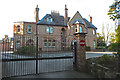
3
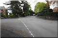
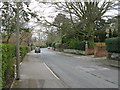
Multiple road junction on Gorsey Lane
A well-to-do residential corner of Altrincham.
Image: © Bill Boaden
Taken: 2 May 2015
0.17 miles
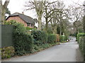
4
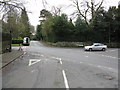
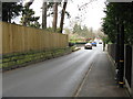
Altrincham - Highgate Road Junction
Despite the road markings, Gorsey Lane continues from the narrow lane on the left to the road exiting mid-right, reflecting the first road here.
Image: © Peter Whatley
Taken: 31 Mar 2009
0.18 miles
7
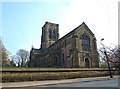
St Margaret's Church, Bowdon, Cheshire
Image: © Anthony O'Neil
Taken: 28 Mar 2011
0.25 miles