IMAGES TAKEN NEAR TO
Reddy Lane, ALTRINCHAM, WA14 3RA
Introduction
This page details the photographs taken nearby to Reddy Lane, WA14 3RA by members of the Geograph project.
The Geograph project started in 2005 with the aim of publishing, organising and preserving representative images for every square kilometre of Great Britain, Ireland and the Isle of Man.

There are currently over 7.5m images from over14,400 individuals and you can help contribute to the project by visiting https://www.geograph.org.uk
Image Map
Images are licensed for reuse under creativecommons.org/licenses/by-sa/2.0
Notes
- Clicking on the map will re-center to the selected point.
- The higher the marker number, the further away the image location is from the centre of the postcode.
Image Listing (6 Images Found)
Images are licensed for reuse under creativecommons.org/licenses/by-sa/2.0
Image
Details
Distance
1
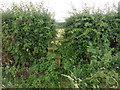
Overgrown stile near Little Bollington
A passable but little-used footpath, Little Bollington FP4.
Image: © Dave Dunford
Taken: 30 Jul 2015
0.13 miles
2
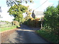
Reddy Lane
Looking north east near Arthill Farm.
Image: © JThomas
Taken: 5 Nov 2016
0.13 miles
3
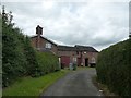
Arthill Farm
Technically the public footpath runs down the drive and right in front of this building, but the de facto path (as indicated by an on-site waymark) runs in front of some open-fronted barns to the right of the photographer.
Image: © Dave Dunford
Taken: 30 Jul 2015
0.15 miles
4
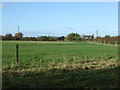
Grazing near Arthill Farm
West of Reddy Lane.
Image: © JThomas
Taken: 5 Nov 2016
0.15 miles
5
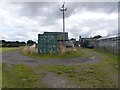
Arthill Farm
Official line of public footpath is to the right of the telegraph pole, past the glasshouse and farmhouse; the de facto line (note fingerpost at left-hand corner of green-painted container) is to the left.
Image: © Dave Dunford
Taken: 30 Jul 2015
0.17 miles
6
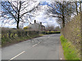
Reddy Lane
Between Little Bollington and Arthill.
Image: © David Dixon
Taken: 16 Apr 2013
0.21 miles