IMAGES TAKEN NEAR TO
Birkinheath Lane, ALTRINCHAM, WA14 3QL
Introduction
This page details the photographs taken nearby to Birkinheath Lane, WA14 3QL by members of the Geograph project.
The Geograph project started in 2005 with the aim of publishing, organising and preserving representative images for every square kilometre of Great Britain, Ireland and the Isle of Man.

There are currently over 7.5m images from over14,400 individuals and you can help contribute to the project by visiting https://www.geograph.org.uk
Image Map
Images are licensed for reuse under creativecommons.org/licenses/by-sa/2.0
Notes
- Clicking on the map will re-center to the selected point.
- The higher the marker number, the further away the image location is from the centre of the postcode.
Image Listing (13 Images Found)
Images are licensed for reuse under creativecommons.org/licenses/by-sa/2.0
Image
Details
Distance
2
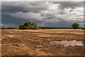
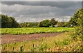
Birkin House
Fields at Birkin House Farm.
Image: © Peter McDermott
Taken: 11 Aug 2014
0.13 miles
4
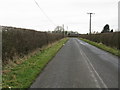
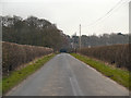
Public footpath toward Birkin House
Taken from Birkinheath Lane.
Image: © Ian S
Taken: 5 Jan 2022
0.16 miles
6
Birkin House
Crops at Birkin House Farm.
Image: © Peter McDermott
Taken: 11 Aug 2014
0.21 miles
7
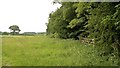
Edge of the woods at Ashley, Cheshire
Image: © Anthony O'Neil
Taken: 19 Jun 2010
0.22 miles
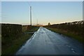
9
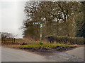
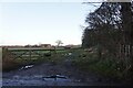
Junction of Three Lanes
The junction of Cherry Tree Lane/Marsh Lane and Birkinheath Lane.
Image: © David Dixon
Taken: 19 Mar 2013
0.24 miles
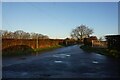
10
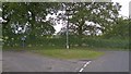
Junction of lanes near Briddon Weir, Rostherne, Cheshire
Image: © Anthony O'Neil
Taken: 19 Jun 2010
0.24 miles