IMAGES TAKEN NEAR TO
Ashley Mill Lane, ALTRINCHAM, WA14 3PX
Introduction
This page details the photographs taken nearby to Ashley Mill Lane, WA14 3PX by members of the Geograph project.
The Geograph project started in 2005 with the aim of publishing, organising and preserving representative images for every square kilometre of Great Britain, Ireland and the Isle of Man.

There are currently over 7.5m images from over14,400 individuals and you can help contribute to the project by visiting https://www.geograph.org.uk
Image Map
Images are licensed for reuse under creativecommons.org/licenses/by-sa/2.0
Notes
- Clicking on the map will re-center to the selected point.
- The higher the marker number, the further away the image location is from the centre of the postcode.
Image Listing (12 Images Found)
Images are licensed for reuse under creativecommons.org/licenses/by-sa/2.0
Image
Details
Distance
2
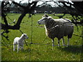
Sheep and lamb, Ryecroft Farm
Viewed through a gap in the fence from the public footpath.
Image: © Richard Sutcliffe
Taken: 26 Mar 2017
0.12 miles
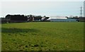
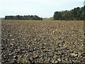
3
Trafford's Bank Covert and ploughed field
Image: © Richard Sutcliffe
Taken: 26 Mar 2017
0.14 miles
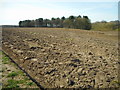
4
Ploughed field and woodland, Ryecroft Farm
Image: © Richard Sutcliffe
Taken: 26 Mar 2017
0.15 miles
5
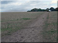
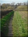
Footpath
Footpath across a recently cut crop field. Ryecroft farm is situated nearby.
Image: © Stephen Burton
Taken: 23 Sep 2011
0.16 miles
6
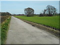
Road from Ryecroft Farm
The trees on the right surround a kettle hole pond.
Image: © Richard Sutcliffe
Taken: 26 Mar 2017
0.18 miles
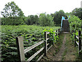
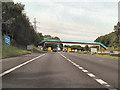
9
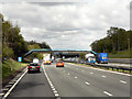
Westbound M56, Access Bridge for Ryecroft Farm
Image: © David Dixon
Taken: 13 May 2013
0.21 miles