IMAGES TAKEN NEAR TO
Stanhope Road, ALTRINCHAM, WA14 3JZ
Introduction
This page details the photographs taken nearby to Stanhope Road, WA14 3JZ by members of the Geograph project.
The Geograph project started in 2005 with the aim of publishing, organising and preserving representative images for every square kilometre of Great Britain, Ireland and the Isle of Man.

There are currently over 7.5m images from over14,400 individuals and you can help contribute to the project by visiting https://www.geograph.org.uk
Image Map
Images are licensed for reuse under creativecommons.org/licenses/by-sa/2.0
Notes
- Clicking on the map will re-center to the selected point.
- The higher the marker number, the further away the image location is from the centre of the postcode.
Image Listing (7 Images Found)
Images are licensed for reuse under creativecommons.org/licenses/by-sa/2.0
Image
Details
Distance
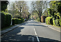
3
The Springs
A private road off Park Road, Bowdon.
Image: © Richard Sutcliffe
Taken: 27 Mar 2017
0.18 miles
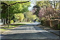
5
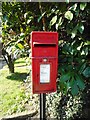
Postbox, The Springs
Postbox number WA14 20 at the junction of The Springs and Park Road, Bowdon.
Image: © Richard Sutcliffe
Taken: 27 Mar 2017
0.20 miles
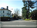
6
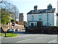
Junction of Church Brow and Langham Road
The tower of St Mary the Virgin is in the distance.
Image: © Richard Sutcliffe
Taken: 27 Mar 2017
0.23 miles
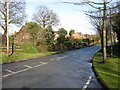
7
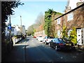
Church Brow, Bowdon
Looking down Church Brow towards Park Road (B5160).
Image: © Richard Sutcliffe
Taken: 27 Mar 2017
0.23 miles