IMAGES TAKEN NEAR TO
South Downs Road, ALTRINCHAM, WA14 3HY
Introduction
This page details the photographs taken nearby to South Downs Road, WA14 3HY by members of the Geograph project.
The Geograph project started in 2005 with the aim of publishing, organising and preserving representative images for every square kilometre of Great Britain, Ireland and the Isle of Man.

There are currently over 7.5m images from over14,400 individuals and you can help contribute to the project by visiting https://www.geograph.org.uk
Image Map
Images are licensed for reuse under creativecommons.org/licenses/by-sa/2.0
Notes
- Clicking on the map will re-center to the selected point.
- The higher the marker number, the further away the image location is from the centre of the postcode.
Image Listing (57 Images Found)
Images are licensed for reuse under creativecommons.org/licenses/by-sa/2.0
Image
Details
Distance
1
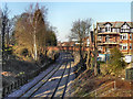
Heather Road Bridge
The bridge carrying Heather Road (B5162) over the railway at Hale.
Image: © David Dixon
Taken: 16 Jan 2012
0.03 miles
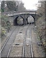
2
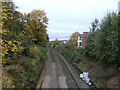
Railway towards Knutsford
Looking south from the bridge on Heather Road.
Image: © JThomas
Taken: 29 Oct 2016
0.03 miles
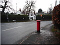
3
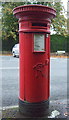
Victorian postbox on Heather Road, Hale
Postbox No. WA14 18.
See Image] for wider view
Image: © JThomas
Taken: 29 Oct 2016
0.05 miles
4
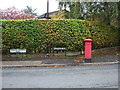
Victorian postbox on Heather Road, Hale
Postbox No. WA14 18.
See Image] for close up.
Image: © JThomas
Taken: 29 Oct 2016
0.05 miles
5
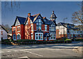
Living in Hale (2)
Wolf Grange, Ashley Road
Image: © Anthony O'Neil
Taken: 23 Feb 2023
0.06 miles
6
Ashley Road Bridge
The bridge carries Ashley Road (the B5367), and large pipe - presumably a water main, over the railway line to Chester.
Photographed from the bridge at Heather Road.
Image: © Richard Sutcliffe
Taken: 18 Dec 2016
0.06 miles
7
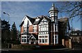
The former Bleeding Wolf pub
Now private accommodation.
Image: © Richard Sutcliffe
Taken: 14 Feb 2016
0.06 miles
8
Junction of Heather Road and South Downs Road
The Victorian postbox can be seen in more detail here [http://www.geograph.org.uk/photo/5177760].
Image: © Richard Sutcliffe
Taken: 18 Dec 2016
0.06 miles
9
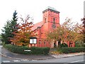
Hale United Reformed Church
On the corner of Cecil Road, Hale, this church is circa 1904.
Image: © Roger May
Taken: 15 Nov 2005
0.06 miles
10
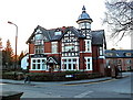
Luxury apartments, Ashley Road, Hale
Formerly the Bleeding Wolf hotel. Other accommodation was created in new-build property at the rear, alongside the Manchester/Chester railway line which runs at the back. The rather strange name for the pub is said, by some authorities, to derive from its having been on land where the last wolf in England was slain.
Image: © Anthony O'Neil
Taken: 28 Jan 2011
0.06 miles