IMAGES TAKEN NEAR TO
York Road, ALTRINCHAM, WA14 3EF
Introduction
This page details the photographs taken nearby to York Road, WA14 3EF by members of the Geograph project.
The Geograph project started in 2005 with the aim of publishing, organising and preserving representative images for every square kilometre of Great Britain, Ireland and the Isle of Man.

There are currently over 7.5m images from over14,400 individuals and you can help contribute to the project by visiting https://www.geograph.org.uk
Image Map
Images are licensed for reuse under creativecommons.org/licenses/by-sa/2.0
Notes
- Clicking on the map will re-center to the selected point.
- The higher the marker number, the further away the image location is from the centre of the postcode.
Image Listing (36 Images Found)
Images are licensed for reuse under creativecommons.org/licenses/by-sa/2.0
Image
Details
Distance
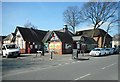
1
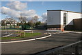
Bowdon Church School
The new Bowdon Church School and car park, Grange Road.
Image: © Richard Sutcliffe
Taken: 14 Feb 2016
0.06 miles
2
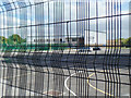
Through the mesh
Bowdon Church School
Image: © Anthony O'Neil
Taken: 31 Aug 2016
0.09 miles
3
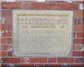
Foundation stone for former infants school, Bowdon Vale
Foundation stone for the infants school, which was built on land given by the Stamford family.
The inscription reads:
A.M.D.C.
This stone was laid by
Penelope
Countess of Stamford
April 28th 1909
The building is now a Co-op store [http://www.geograph.org.uk/photo/5329903].
Image: © Richard Sutcliffe
Taken: 27 Mar 2017
0.11 miles
4
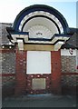
Co-op, Bowdon Vale
This ornate canopy, dated 1909, seems very out of place on a Co-op store. The reason is that the building was originally built as an infants school on land given by the Stamford family. The foundation stone, laid by the Countess of Stamford, can be seen at the bottom [http://www.geograph.org.uk/photo/5329959].
Image: © Richard Sutcliffe
Taken: 27 Mar 2017
0.11 miles
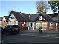
5
Co-op store, Bowdon Vale
Now a Co-op store (and incorporating a post office), it was originally built as an infants school on land given by the Stamford family. The foundation stone, laid by the Countess of Stamford, can still be seen on the side of the building [http://www.geograph.org.uk/photo/5329959].
Image: © Richard Sutcliffe
Taken: 27 Mar 2017
0.12 miles
6
Co-operative food store and Post Office
On Vicarage Lane.
Showing position of Postbox No. WA14 23.
See Image] for postbox.
Image: © JThomas
Taken: 5 Nov 2016
0.12 miles
7
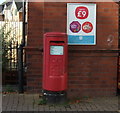
Elizabeth II postbox on Vicarage Lane
Outside Post Office.
Postbox No. WA14 23.
See Image] for context.
Image: © JThomas
Taken: 5 Nov 2016
0.12 miles
8
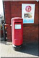
Postbox, Vicarage Lane Post Office
The postbox (number WA14 23) is situated just outside the Post Office, which is in the Co-op store on Vicarage Lane.
Image: © Richard Sutcliffe
Taken: 27 Mar 2017
0.12 miles
9
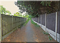
Foot and Cycle path
Near Rosehill, Bowdon
Image: © Anthony O'Neil
Taken: 31 Aug 2016
0.12 miles
10
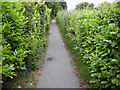
Footpath from York Drive to Grange Road
At the start of the footpath it runs beside the Bowdon Cricket Hockey and Squash Club on the right and private houses on the left. Nothing much can be seen of either through the Laurel hedges.
Image: © Richard Sutcliffe
Taken: 19 Jun 2015
0.12 miles