IMAGES TAKEN NEAR TO
Priory Road, ALTRINCHAM, WA14 3BT
Introduction
This page details the photographs taken nearby to Priory Road, WA14 3BT by members of the Geograph project.
The Geograph project started in 2005 with the aim of publishing, organising and preserving representative images for every square kilometre of Great Britain, Ireland and the Isle of Man.

There are currently over 7.5m images from over14,400 individuals and you can help contribute to the project by visiting https://www.geograph.org.uk
Image Map
Images are licensed for reuse under creativecommons.org/licenses/by-sa/2.0
Notes
- Clicking on the map will re-center to the selected point.
- The higher the marker number, the further away the image location is from the centre of the postcode.
Image Listing (17 Images Found)
Images are licensed for reuse under creativecommons.org/licenses/by-sa/2.0
Image
Details
Distance
1
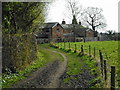
Bowgreen, footpath
Footpath from Bowgreen, on the edge of the green belt, to Ashley and the River Bollin. http://www.trafford.gov.uk/cme/live/cme3267.htm
Image: © Mike Faherty
Taken: 16 May 2009
0.02 miles
3
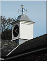
Clock and weather vane, Priory Farm
Image: © Richard Sutcliffe
Taken: 26 Mar 2017
0.06 miles
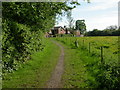
5
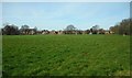
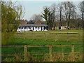
Field beside Priory Farm
The houses in the distance are on Priory Lane.
Image: © Richard Sutcliffe
Taken: 26 Mar 2017
0.10 miles
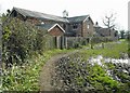
6
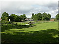
Bowdon Vale Cricket Club
Beyond the preserved tractor; on the edge of the green belt. http://www.bowdonvalecc.org.uk/
Image: © Mike Faherty
Taken: 16 May 2009
0.11 miles
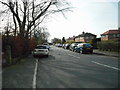
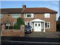
9
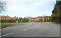
Corner of Priory Road and Bow Lane
Image: © Richard Sutcliffe
Taken: 26 Mar 2017
0.13 miles