IMAGES TAKEN NEAR TO
Delamer Road, ALTRINCHAM, WA14 2NT
Introduction
This page details the photographs taken nearby to Delamer Road, WA14 2NT by members of the Geograph project.
The Geograph project started in 2005 with the aim of publishing, organising and preserving representative images for every square kilometre of Great Britain, Ireland and the Isle of Man.

There are currently over 7.5m images from over14,400 individuals and you can help contribute to the project by visiting https://www.geograph.org.uk
Image Map
Images are licensed for reuse under creativecommons.org/licenses/by-sa/2.0
Notes
- Clicking on the map will re-center to the selected point.
- The higher the marker number, the further away the image location is from the centre of the postcode.
Image Listing (66 Images Found)
Images are licensed for reuse under creativecommons.org/licenses/by-sa/2.0
Image
Details
Distance
1
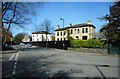
Houses on Cavendish Road
Seen from the junction of Cavendish Road and Delamer Road.
Image: © Richard Sutcliffe
Taken: 27 Mar 2017
0.06 miles
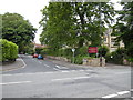
2
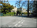
Houses on Delamer Road
Seen from the junction of Cavendish Road and Delamer Road.
Image: © Richard Sutcliffe
Taken: 27 Mar 2017
0.07 miles
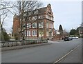
3
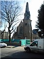
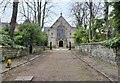
Former Trinity United Reformed Church
A Grade II listed building dating from 1872 on Delamer Road, currently being converted into flats.
Image: © Richard Sutcliffe
Taken: 27 Mar 2017
0.08 miles
4
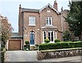
Around Bowdon (15)
'Downs House', Higher Downs: Blue Plaque for author and teacher, Allison Uttley (1884 - 1976), who lived here 1924 to 1938. Wrote 100 books, notably a series for children.
Image: © Anthony O'Neil
Taken: 27 Mar 2022
0.09 miles
5
Around Bowdon (14)
URCF Church, Beechfield. (Upper Room Christian Fellowship)
Image: © Anthony O'Neil
Taken: 27 Mar 2022
0.13 miles
6
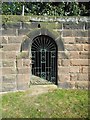
Gate in the wall
An interesting gate in the wall of a house in the private St Mary's Road, Bowdon. There appears to be a short tunnel leading into the garden behind.
Image: © Richard Sutcliffe
Taken: 27 Mar 2017
0.14 miles
7
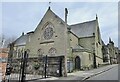
Around Bowdon (13)
Bowdon Downs Church
Image: © Anthony O'Neil
Taken: 27 Mar 2022
0.15 miles
8
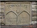
Old Boundary Marker by Higher Downs, Altrincham
Parish Boundary Marker by the UC road, in parish of Altrincham (Trafford District), The Downs, junction with St Johns Road, inset into wall.
Inscription reads:-
: ALTRINCHAM : : TOWNSHIPS : : DUNHAM / MASSEY :
Grade II listed. List Entry Number: 1253113
https://historicengland.org.uk/listing/the-list/list-entry/1253113
Surveyed
Milestone Society National ID: CH_DUMALT01pb
Image: © Milestone Society
Taken: Unknown
0.15 miles
9
Cavendish Road
Junction of Cavendish Road and Ashley Road. Bowdon Preparatory School for Girls is to the right.
Image: © Richard Sutcliffe
Taken: 19 Jun 2015
0.15 miles
10
Around Bowdon (12)
'Woodville House': Pozzoni Architects' HQ
Image: © Anthony O'Neil
Taken: 27 Mar 2022
0.16 miles