IMAGES TAKEN NEAR TO
Garner Close, ALTRINCHAM, WA14 2JH
Introduction
This page details the photographs taken nearby to Garner Close, WA14 2JH by members of the Geograph project.
The Geograph project started in 2005 with the aim of publishing, organising and preserving representative images for every square kilometre of Great Britain, Ireland and the Isle of Man.

There are currently over 7.5m images from over14,400 individuals and you can help contribute to the project by visiting https://www.geograph.org.uk
Image Map
Images are licensed for reuse under creativecommons.org/licenses/by-sa/2.0
Notes
- Clicking on the map will re-center to the selected point.
- The higher the marker number, the further away the image location is from the centre of the postcode.
Image Listing (136 Images Found)
Images are licensed for reuse under creativecommons.org/licenses/by-sa/2.0
Image
Details
Distance
1
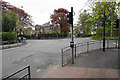
Five-point junction near Altrincham and Hale
The main road passing through is Ashley Road, the B5161.
Image: © Bill Boaden
Taken: 2 May 2015
0.03 miles
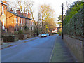
2
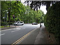
Marlborough Road - Ashley Road junction
Looking from Marlborough Road to the junction with Langham Road (B5161) to the immediate left; Stamford Road to the left; and Ashley Road (B5163) straight on and to the right.
Image: © Richard Sutcliffe
Taken: 19 Jun 2015
0.03 miles
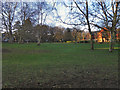
3
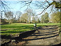
Spring Bank Recreation Ground
A Recreation Ground at the corner of Stamford Road and Ashley Road.
Image: © Richard Sutcliffe
Taken: 26 Mar 2017
0.04 miles
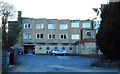
4
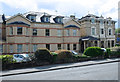
Former Bowdon Hotel
Originally a long-established local business, more recently extended by an international hotel chain.
Image: © Anthony O'Neil
Taken: 2 May 2017
0.04 miles
5
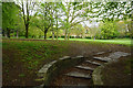
Green space by Stamford Road
A good place to walk the dog which is well maintained, but there are no municipal park signs.
Image: © Bill Boaden
Taken: 2 May 2015
0.04 miles
8
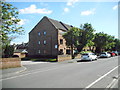
Hale Court, Willowtree Road
Flats built on the site of the former Hale Cinema, which was demolished in 1978.
Image: © Richard Sutcliffe
Taken: 22 Apr 2017
0.08 miles
9
Bowdon Hotel
The rear of the Mercure Bowdon Hotel, viewed from Marlborough Road. The circular windows are part of the hotel's leisure centre.
Image: © Richard Sutcliffe
Taken: 27 Mar 2017
0.09 miles
10
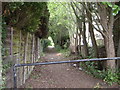
Path between Marlborough Road and Langham Road
This path is a short-cut onto Langham Road from Marlborough Road, down the side of the Bowdon Hotel.
Image: © Richard Sutcliffe
Taken: 19 Jun 2015
0.10 miles