IMAGES TAKEN NEAR TO
Deansgate Lane, ALTRINCHAM, WA14 1SY
Introduction
This page details the photographs taken nearby to Deansgate Lane, WA14 1SY by members of the Geograph project.
The Geograph project started in 2005 with the aim of publishing, organising and preserving representative images for every square kilometre of Great Britain, Ireland and the Isle of Man.

There are currently over 7.5m images from over14,400 individuals and you can help contribute to the project by visiting https://www.geograph.org.uk
Image Map
Images are licensed for reuse under creativecommons.org/licenses/by-sa/2.0
Notes
- Clicking on the map will re-center to the selected point.
- The higher the marker number, the further away the image location is from the centre of the postcode.
Image Listing (52 Images Found)
Images are licensed for reuse under creativecommons.org/licenses/by-sa/2.0
Image
Details
Distance
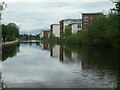
1
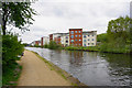
Blocks of flats by the Bridgewater Canal
Image: © Bill Boaden
Taken: 2 May 2015
0.01 miles
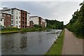
3
The Bridge Apartments, Deansgate Lane, Timperley
On the east bank of the Bridgewater canal.
Image: © Christine Johnstone
Taken: 22 May 2021
0.03 miles
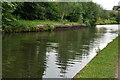
5
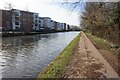
Bridgewater Canal towards Manchester Road Bridge
Image: © Ian S
Taken: 1 Mar 2022
0.04 miles
6
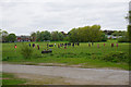
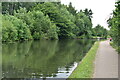
Saturday morning football on Salisbury Fields
Viewed from the Bridgewater Canal towpath.
Image: © Bill Boaden
Taken: 2 May 2015
0.05 miles
7
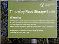
Timperley Flood Storage Basin - Warning Sign
Image: © David Dixon
Taken: 14 Jan 2012
0.07 miles
8

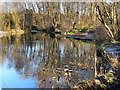
Pond by Timperley Flood Storage Basin
In the low-lying land by Timperley Brook.
Image: © Bill Boaden
Taken: 2 May 2015
0.08 miles