IMAGES TAKEN NEAR TO
High Street, ALTRINCHAM, WA14 1PZ
Introduction
This page details the photographs taken nearby to High Street, WA14 1PZ by members of the Geograph project.
The Geograph project started in 2005 with the aim of publishing, organising and preserving representative images for every square kilometre of Great Britain, Ireland and the Isle of Man.

There are currently over 7.5m images from over14,400 individuals and you can help contribute to the project by visiting https://www.geograph.org.uk
Image Map
Images are licensed for reuse under creativecommons.org/licenses/by-sa/2.0
Notes
- Clicking on the map will re-center to the selected point.
- The higher the marker number, the further away the image location is from the centre of the postcode.
Image Listing (489 Images Found)
Images are licensed for reuse under creativecommons.org/licenses/by-sa/2.0
Image
Details
Distance
1
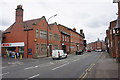
Dunham Road, Altrincham
The A56 heading into Altrincham town centre, though the active part of the town centre is off to the right.
Image: © Bill Boaden
Taken: 2 May 2015
0.02 miles
2
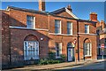
Stamford Estates Office
Grade 2 listed building at 18, High Street, Altrincham.
The Grey family, who became Earls of Stamford in 1628, were domiciled at Dunham Massey Hall, near Altrincham, where they remained until the death - without issue - of the 10th Earl, who arranged that the property pass to the National Trust.
The 1st Earl had been Baron Grey of Groby (a village in Leicestershire) and the name is commemorated as adjacent Groby Road which runs past St Vincent's Church to the edge of Bowdon.
Dunham Massey Estate, with its Hall and deer park, has become much used by townspeople and visitors,
and the Stamford name has been used on pubs and public buildings. It is also reflected in Stamford Park, close to the centre, which was once part of the ancient Hale Moss and was gifted to the town by the Earl of Stamford in 1878. See further details relating to this settlement: Image
Image: © Anthony O'Neil
Taken: 6 Aug 2023
0.02 miles
3
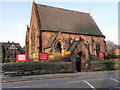
Dunham Road Unitarian Chapel
The Unitarian Chapel was founded in 1814; this building dates from 1872.
Image: © David Dixon
Taken: 12 Jan 2012
0.03 miles
4
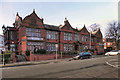
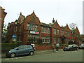
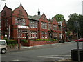
Altrincham Town Hall
The Town Hall on the right was built in 1900 with Dutch gables and the Extension on its left in 1930.
For more details, see http://www.communigate.co.uk/chesh/altrincham/page2.phtml (Altrincham History Society)
Image: © David Dixon
Taken: 12 Jan 2012
0.04 miles
5
Former Altrincham Town Hall
The building dates from 1900 but surprisingly appears not to be listed. It now hosts various community organisations.
Image: © Stephen Craven
Taken: 11 Mar 2017
0.04 miles
6
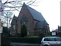
Altrincham, Unitarian chapel
Dunham Road Unitarian Chapel, built 1872. For more information, see http://www.altrinchamunitarians.org/
Image: © Mike Faherty
Taken: 22 Jan 2009
0.04 miles
7
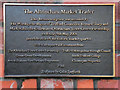
The Altrincham Market Trader - Plaque
Plaque on the Wall outside the Town Hall, near Image
Image: © David Dixon
Taken: 12 Jan 2012
0.04 miles
8
Altrincham Town Hall
In Market Street; built 1900, extended 1930. Used as a town hall until local government reorganisation in 1974. Internally, fine heraldic stained glass; the old council chamber has a barrel-vaulted roof. http://www.altrincham.org.uk/History.asp
Image: © Mike Faherty
Taken: 17 May 2009
0.04 miles
9
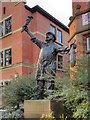
The Altrincham Market Trader
This bronze statue, the work of sculptor Colin Spofforth, stands outside Image It was unveiled in 2008. A plaque on the wall outside the Town Hall, gives more detail (Image]).
Image: © David Dixon
Taken: 12 Jan 2012
0.04 miles
10
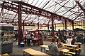
Sunday trading
Perhaps for the first time in its 800 year history, Altrincham is experimenting with opening its covered Charter market on a Sunday, but to a different group of traders, and with something of a party atmosphere. The Market area of the town is central to plans for regeneration and renewal after a period of decline. It will be in line for more radical change once the nearby General Hospital transfers to Stamford New Road and leaves its old buildings open to redevelopment.
Image: © Anthony O'Neil
Taken: 3 Aug 2014
0.05 miles